Alwar geodata
Alwar (Rajasthan) is a populated place; located in India in Asia/Kolkata (GMT+5.5) time zone. With population of 283,228 people, there are 155 cities with bigger population in this country. Compared to other cities in India, 82.3% of cities are located further ↓South; 66.9% of cities are located further →East and 62.7% of cities have lower elevation than Alwar. Note1


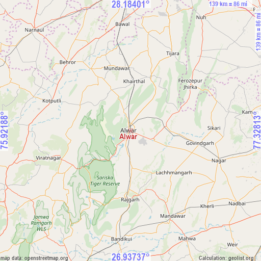
Alwar GPS coordinates[2]
27° 33' 44.856" North, 76° 37' 30" East
| Map corner | latitude | longitude |
|---|---|---|
| Upper-left | 28.18401°, | 75.92188° |
| Center: | 27.56246°, | 76.625° |
| Lower-right: | 26.93737°, | 77.32813° |
| Map W x H: | 138.6×138.6 km | = 86.1×86.1mi |
| max Lat: | 34.9274° ⇑17.7% North |
| Alwar: | 27.56246° |
| min Lat: | ⇓82.3% South 8.09008° |
| min Long | Alwar | max Long |
| 68.82655° | 76.625° | 96.81° |
| W 33.1%⇐ | ⇒66.9% E |
Elevation
Elevation of Alwar is 269 m = 883 ft, and this is 26.6 m = 87 ft below average elevation for this country.
| Max E: |
3681 m = 12077 ft | 37.3% |
| Avg. | 295.6 m = 970 ft | |
| Alwar | 269 m = 883 ft | |
Min E: |
1 m = 3 ft | 62.7% |
See also: Alwar elevation on elevation.city.
Geographical zone
Alwar is located in North temperate zone (between Tropic of Cancer and the Arctic Circle). Distance of this Northern Tropic circle is 458.7 km =285 mi to South.| Distance of | km | miles | from Alwar |
|---|---|---|---|
| North Pole | 6942.4 | 4313.8 | to North |
| Arctic Circle | 4336.5 | 2694.6 | to North |
| Tropic Cancer | 458.7 | 285 | to South |
| Equator | 3064.7 | 1904.3 | to South |


Nearby cities:
15 places around Alwar: (largest is in red/bold)
• Abhaneri
61.7 km =38.3 mi,  181°
181°
• Baswa
46.1 km =28.6 mi,  185°
185°
• Behror
49.6 km =30.8 mi,  316°
316°
• Bāndīkūi
57.1 km =35.5 mi, 185°
• Bāwal
56.8 km =35.3 mi,  355°
355°
• Fīrozpur Jhirka
40.3 km =25 mi,  51°
51°
• Govindgarh
37.5 km =23.3 mi,  99°
99°
• Kishangarh
30.3 km =18.8 mi,  19°
19°
• Kotputli
44.7 km =27.8 mi,  290°
290°
• Kāman
64.3 km =40 mi,  80°
80°
• Mahwah
64.9 km =40.3 mi,  152°
152°
• Mandāwar
34.3 km =21.3 mi,  347°
347°
• Nagar
49.2 km =30.6 mi,  108°
108°
• Rājgarh
36.2 km =22.5 mi, 180°
• Tijāra
47.1 km =29.3 mi,  28°
28°
In other languages:
- In Spanish: Álvaro
- In France: District d'Alwar
- In Italian: Alvaro
- In Russian: Алвар
- In Chinese: 阿尔瓦尔
Sources, notices
• [Note1] Compared only with cities in India existing in our database
• [Src1] Map data: © OpenStreetMap contributors (CC-BY-SA)
• [Src2] Other city data from geonames.org with taken over terms of usage.
• [Src3] Geographical zone / Annual Mean Temperature by Robert A. Rohde @ Wikipedia
