Tijāra geodata
Tijāra (Rajasthan) is a populated place; located in India in Asia/Kolkata (GMT+5.5) time zone. With population of 21,833 people, there are 1911 cities with bigger population in this country. Compared to other cities in India, 84.2% of cities are located further ↓South; 64.7% of cities are located further →East and 66.6% of cities have lower elevation than Tijāra. Note1


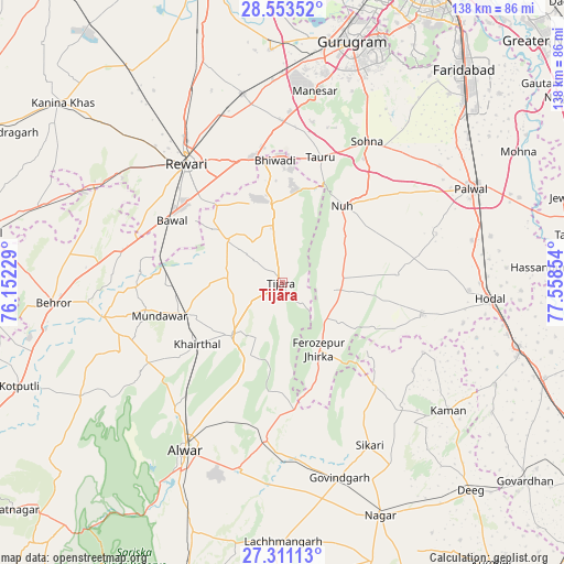
Tijāra GPS coordinates[2]
27° 56' 2.796" North, 76° 51' 19.476" East
| Map corner | latitude | longitude |
|---|---|---|
| Upper-left | 28.55352°, | 76.15229° |
| Center: | 27.93411°, | 76.85541° |
| Lower-right: | 27.31113°, | 77.55854° |
| Map W x H: | 138.1×138.1 km | = 85.8×85.8mi |
| max Lat: | 34.9274° ⇑15.8% North |
| Tijāra: | 27.93411° |
| min Lat: | ⇓84.2% South 8.09008° |
| min Long | Tijāra | max Long |
| 68.82655° | 76.85541° | 96.81° |
| W 35.3%⇐ | ⇒64.7% E |
Elevation
Elevation of Tijāra is 299 m = 981 ft, and this is 3.4 m = 11 ft above average elevation for this country.
| Max E: |
3681 m = 12077 ft | 33.4% |
| Tijāra | 299 m 981 ft | |
| Avg. | 295.6 m = 970 ft | |
Min E: |
1 m = 3 ft | 66.6% |
See also: India elevation on elevation.city.
Geographical zone
Tijāra is located in North temperate zone (between Tropic of Cancer and the Arctic Circle). Distance of this Northern Tropic circle is 500.1 km =310.7 mi to South.| Distance of | km | miles | from Tijāra |
|---|---|---|---|
| North Pole | 6901.1 | 4288.1 | to North |
| Arctic Circle | 4295.2 | 2668.9 | to North |
| Tropic Cancer | 500.1 | 310.7 | to South |
| Equator | 3106 | 1930 | to South |


Nearby cities:
15 places around Tijāra: (largest is in red/bold)
• Alwar
47.1 km =29.3 mi,  208°
208°
• Bhiwadi
30.7 km =19.1 mi,  0°
0°
• Bāwal
30.8 km =19.1 mi,  299°
299°
• Dhāruhera
30.7 km =19.1 mi,  349°
349°
• Fīrozpur Jhirka
18.4 km =11.4 mi,  151°
151°
• Govindgarh
49.9 km =31 mi,  163°
163°
• Hodal
50.5 km =31.4 mi,  95°
95°
• Kishangarh
17.8 km =11.1 mi,  223°
223°
• Mandāwar
31 km =19.3 mi,  255°
255°
• Nūh
23.6 km =14.7 mi,  37°
37°
• Pataudi
44.2 km =27.5 mi, 350°
• Pūnāhāna
35.2 km =21.9 mi, 102°
• Rewāri
37.5 km =23.3 mi,  321°
321°
• Sohna
40.5 km =25.2 mi,  30°
30°
• Tāoru
32.2 km =20 mi,  16°
16°
Sources, notices
• [Note1] Compared only with cities in India existing in our database
• [Src1] Map data: © OpenStreetMap contributors (CC-BY-SA)
• [Src2] Other city data from geonames.org with taken over terms of usage.
• [Src3] Geographical zone / Annual Mean Temperature by Robert A. Rohde @ Wikipedia
