Nūh geodata
Nūh (Haryana) is a populated place; located in India in Asia/Kolkata (GMT+5.5) time zone. With population of 12,698 people, there are 2680 cities with bigger population in this country. Compared to other cities in India, 85% of cities are located further ↓South; 63.1% of cities are located further →East and 50.2% of cities have higher elevation than Nūh. Note1


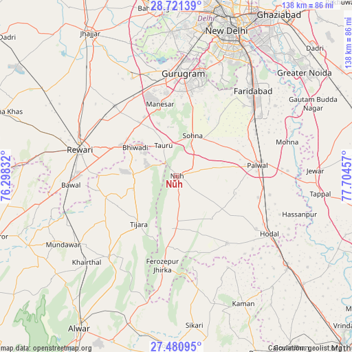
Nūh GPS coordinates[2]
28° 6' 10.656" North, 77° 0' 5.184" East
| Map corner | latitude | longitude |
|---|---|---|
| Upper-left | 28.72139°, | 76.29832° |
| Center: | 28.10296°, | 77.00144° |
| Lower-right: | 27.48095°, | 77.70457° |
| Map W x H: | 137.9×137.9 km | = 85.7×85.7mi |
| max Lat: | 34.9274° ⇑15% North |
| Nūh: | 28.10296° |
| min Lat: | ⇓85% South 8.09008° |
| min Long | Nūh | max Long |
| 68.82655° | 77.00144° | 96.81° |
| W 36.9%⇐ | ⇒63.1% E |
Elevation
Elevation of Nūh is 200 m = 656 ft, and this is 95.6 m = 314 ft below average elevation for this country.
| Max E: |
3681 m = 12077 ft | 50.2% |
| Avg. | 295.6 m = 970 ft | |
| Nūh | 200 m = 656 ft | |
Min E: |
1 m = 3 ft | 49.8% |
See also: India elevation on elevation.city.
Geographical zone
Nūh is located in North temperate zone (between Tropic of Cancer and the Arctic Circle). Distance of this Northern Tropic circle is 518.8 km =322.4 mi to South.| Distance of | km | miles | from Nūh |
|---|---|---|---|
| North Pole | 6882.3 | 4276.5 | to North |
| Arctic Circle | 4276.4 | 2657.2 | to North |
| Tropic Cancer | 518.8 | 322.4 | to South |
| Equator | 3124.8 | 1941.7 | to South |


Nearby cities:
15 places around Nūh: (largest is in red/bold)
• Bhiwadi
18.2 km =11.3 mi,  310°
310°
• Bāwal
41.2 km =25.6 mi,  265°
265°
• Dhāruhera
23.1 km =14.4 mi,  299°
299°
• Farrukhnagar
42.1 km =26.2 mi,  335°
335°
• Fīrozpur Jhirka
35.4 km =22 mi,  189°
189°
• Gurgaon
39.8 km =24.7 mi,  3°
3°
• Hodal
42.9 km =26.7 mi,  123°
123°
• Kishangarh
41.3 km =25.7 mi,  220°
220°
• Palwal
32.1 km =19.9 mi,  81°
81°
• Pataudi
33 km =20.5 mi,  318°
318°
• Pūnāhāna
33.2 km =20.6 mi,  143°
143°
• Rewāri
39.1 km =24.3 mi,  285°
285°
• Sohna
17.2 km =10.7 mi,  21°
21°
• Tijāra
23.6 km =14.7 mi, 217°
• Tāoru
13.1 km =8.1 mi, 337°
Sources, notices
• [Note1] Compared only with cities in India existing in our database
• [Src1] Map data: © OpenStreetMap contributors (CC-BY-SA)
• [Src2] Other city data from geonames.org with taken over terms of usage.
• [Src3] Geographical zone / Annual Mean Temperature by Robert A. Rohde @ Wikipedia
