Egra geodata
Egra (West Bengal) is a populated place; located in India in Asia/Kolkata (GMT+5.5) time zone. With population of 32,832 people, there are 1328 cities with bigger population in this country. Compared to other cities in India, 57% of cities are located further ↑North; 90.3% of cities are located further ←West and 97.4% of cities have higher elevation than Egra. Note1


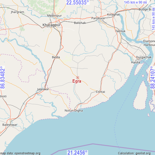
Egra GPS coordinates[2]
21° 53' 58.092" North, 87° 32' 16.584" East
| Map corner | latitude | longitude |
|---|---|---|
| Upper-left | 22.55035°, | 86.83482° |
| Center: | 21.89947°, | 87.53794° |
| Lower-right: | 21.2456°, | 88.24107° |
| Map W x H: | 145.1×145.1 km | = 90.2×90.2mi |
| max Lat: | 34.9274° ⇑57% North |
| Egra: | 21.89947° |
| min Lat: | ⇓43% South 8.09008° |
| min Long | Egra | max Long |
| 68.82655° | 87.53794° | 96.81° |
| W 90.3%⇐ | ⇒9.7% E |
Elevation
Elevation of Egra is 9 m = 30 ft, and this is 286.6 m = 940 ft below average elevation for this country.
| Max E: |
3681 m = 12077 ft | 97.4% |
| Avg. | 295.6 m = 970 ft | |
| Egra | 9 m = 30 ft | |
Min E: |
1 m = 3 ft | 2.6% |
See also: India elevation on elevation.city.
Geographical zone
Egra is located in North Torrid zone (between Equator and Tropic of Cancer). Distance of this Northern Tropic circle is 170.9 km =106.2 mi to North.| Distance of | km | miles | from Egra |
|---|---|---|---|
| North Pole | 7572.1 | 4705.1 | to North |
| Arctic Circle | 4966.2 | 3085.9 | to North |
| Tropic Cancer | 170.9 | 106.2 | to North |
| Equator | 2435 | 1513 | to South |


Nearby cities:
15 places around Egra: (largest is in red/bold)
• Balasore
77.1 km =47.9 mi,  234°
234°
• Bāli Chak
51.8 km =32.2 mi,  1°
1°
• Contai
25.5 km =15.8 mi,  121°
121°
• Diamond Harbour
74.2 km =46.1 mi,  63°
63°
• Digha
30.3 km =18.8 mi,  183°
183°
• Haldia
61.6 km =38.3 mi,  73°
73°
• Jaleshwar
34.3 km =21.3 mi,  251°
251°
• Kalaīkunda
58.5 km =36.4 mi,  326°
326°
• Kharagpur
53.6 km =33.3 mi,  335°
335°
• Mahīshādal
55.7 km =34.6 mi, 55°
• Medinīpur
62.1 km =38.6 mi, 339°
• Monoharpur
60.4 km =37.5 mi, 67°
• Remuna
80.3 km =49.9 mi,  239°
239°
• Solap
68.8 km =42.8 mi, 68°
• Tamlūk
59.9 km =37.2 mi,  41°
41°
Sources, notices
• [Note1] Compared only with cities in India existing in our database
• [Src1] Map data: © OpenStreetMap contributors (CC-BY-SA)
• [Src2] Other city data from geonames.org with taken over terms of usage.
• [Src3] Geographical zone / Annual Mean Temperature by Robert A. Rohde @ Wikipedia
