Jaleshwar geodata
Jaleshwar (Odisha) is a populated place; located in India in Asia/Kolkata (GMT+5.5) time zone. With population of 23,280 people, there are 1819 cities with bigger population in this country. Compared to other cities in India, 57.5% of cities are located further ↑North; 89.7% of cities are located further ←West and 91.9% of cities have higher elevation than Jaleshwar. Note1


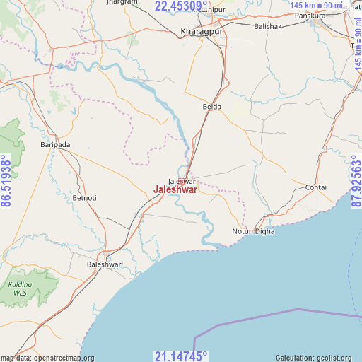
Jaleshwar GPS coordinates[2]
21° 48' 6.336" North, 87° 13' 21" East
| Map corner | latitude | longitude |
|---|---|---|
| Upper-left | 22.45309°, | 86.51938° |
| Center: | 21.80176°, | 87.2225° |
| Lower-right: | 21.14745°, | 87.92563° |
| Map W x H: | 145.2×145.2 km | = 90.2×90.2mi |
| max Lat: | 34.9274° ⇑57.5% North |
| Jaleshwar: | 21.80176° |
| min Lat: | ⇓42.5% South 8.09008° |
| min Long | Jaleshwar | max Long |
| 68.82655° | 87.2225° | 96.81° |
| W 89.7%⇐ | ⇒10.3% E |
Elevation
Elevation of Jaleshwar is 15 m = 49 ft, and this is 280.6 m = 921 ft below average elevation for this country.
| Max E: |
3681 m = 12077 ft | 91.9% |
| Avg. | 295.6 m = 970 ft | |
| Jaleshwar | 15 m = 49 ft | |
Min E: |
1 m = 3 ft | 8.1% |
See also: India elevation on elevation.city.
Geographical zone
Jaleshwar is located in North Torrid zone (between Equator and Tropic of Cancer). Distance of this Northern Tropic circle is 181.8 km =113 mi to North.| Distance of | km | miles | from Jaleshwar |
|---|---|---|---|
| North Pole | 7582.9 | 4711.8 | to North |
| Arctic Circle | 4977 | 3092.6 | to North |
| Tropic Cancer | 181.8 | 113 | to North |
| Equator | 2424.1 | 1506.3 | to South |


Nearby cities:
15 places around Jaleshwar: (largest is in red/bold)
• Balasore
45.5 km =28.3 mi,  220°
220°
• Bāli Chak
71.3 km =44.3 mi,  28°
28°
• Bāsudebpur
91.4 km =56.8 mi,  213°
213°
• Contai
54.4 km =33.8 mi,  92°
92°
• Digha
36.3 km =22.6 mi,  122°
122°
• Egra
34.3 km =21.3 mi,  71°
71°
• Jhārgrām
76.2 km =47.3 mi,  342°
342°
• Kalaīkunda
59.8 km =37.2 mi,  0°
0°
• Kharagpur
60.7 km =37.7 mi,  10°
10°
• Mahīshādal
89.1 km =55.4 mi,  61°
61°
• Medinīpur
69.6 km =43.2 mi, 8°
• Nīlgiri
60.3 km =37.5 mi,  231°
231°
• Remuna
47.3 km =29.4 mi, 229°
• Soro
80.2 km =49.8 mi, 223°
• Tamlūk
91.3 km =56.7 mi,  52°
52°
Sources, notices
• [Note1] Compared only with cities in India existing in our database
• [Src1] Map data: © OpenStreetMap contributors (CC-BY-SA)
• [Src2] Other city data from geonames.org with taken over terms of usage.
• [Src3] Geographical zone / Annual Mean Temperature by Robert A. Rohde @ Wikipedia
