Balasore geodata
Balasore (Odisha) is a populated place; located in India in Asia/Kolkata (GMT+5.5) time zone. With population of 114,321 people, there are 385 cities with bigger population in this country. Compared to other cities in India, 59% of cities are located further ↑North; 89.1% of cities are located further ←West and 88.1% of cities have higher elevation than Balasore. Note1


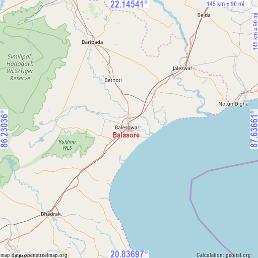
Balasore GPS coordinates[2]
21° 29' 33.576" North, 86° 56' 0.528" East
| Map corner | latitude | longitude |
|---|---|---|
| Upper-left | 22.14541°, | 86.23036° |
| Center: | 21.49266°, | 86.93348° |
| Lower-right: | 20.83697°, | 87.63661° |
| Map W x H: | 145.5×145.5 km | = 90.4×90.4mi |
| max Lat: | 34.9274° ⇑59% North |
| Balasore: | 21.49266° |
| min Lat: | ⇓41% South 8.09008° |
| min Long | Balasore | max Long |
| 68.82655° | 86.93348° | 96.81° |
| W 89.1%⇐ | ⇒10.9% E |
Elevation
Elevation of Balasore is 22 m = 72 ft, and this is 273.6 m = 898 ft below average elevation for this country.
| Max E: |
3681 m = 12077 ft | 88.1% |
| Avg. | 295.6 m = 970 ft | |
| Balasore | 22 m = 72 ft | |
Min E: |
1 m = 3 ft | 11.9% |
See also: Balasore elevation on elevation.city.
Geographical zone
Balasore is located in North Torrid zone (between Equator and Tropic of Cancer). Distance of this Northern Tropic circle is 216.2 km =134.3 mi to North.| Distance of | km | miles | from Balasore |
|---|---|---|---|
| North Pole | 7617.3 | 4733.2 | to North |
| Arctic Circle | 5011.4 | 3113.9 | to North |
| Tropic Cancer | 216.2 | 134.3 | to North |
| Equator | 2389.8 | 1485 | to South |


Nearby cities:
15 places around Balasore: (largest is in red/bold)
• Bhadrakh
65.2 km =40.5 mi,  221°
221°
• Bāsudebpur
46.6 km =29 mi,  207°
207°
• Chāndbāli
82.2 km =51.1 mi,  194°
194°
• Contai
90.1 km =56 mi,  69°
69°
• Digha
62.4 km =38.8 mi,  76°
76°
• Egra
77.1 km =47.9 mi,  54°
54°
• Jaleshwar
45.5 km =28.3 mi,  40°
40°
• Jhārgrām
107.1 km =66.5 mi,  3°
3°
• Jājpur
94.6 km =58.8 mi, 220°
• Kalaīkunda
98.9 km =61.5 mi,  17°
17°
• Kharagpur
102.5 km =63.7 mi, 23°
• Nīlgiri
17.5 km =10.9 mi,  258°
258°
• Patāmundai
108.8 km =67.6 mi,  200°
200°
• Remuna
7.5 km =4.7 mi,  301°
301°
• Soro
34.8 km =21.6 mi,  226°
226°
Sources, notices
• [Note1] Compared only with cities in India existing in our database
• [Src1] Map data: © OpenStreetMap contributors (CC-BY-SA)
• [Src2] Other city data from geonames.org with taken over terms of usage.
• [Src3] Geographical zone / Annual Mean Temperature by Robert A. Rohde @ Wikipedia
