Kalaīkunda geodata
Kalaīkunda (West Bengal) is a populated place; located in India in Asia/Kolkata (GMT+5.5) time zone. With population of 3,232 people, there are 3405 cities with bigger population in this country. Compared to other cities in India, 54.2% of cities are located further ↑North; 89.7% of cities are located further ←West and 76.5% of cities have higher elevation than Kalaīkunda. Note1


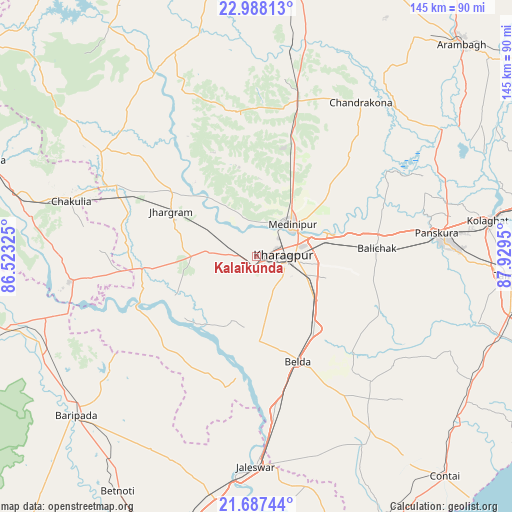
Kalaīkunda GPS coordinates[2]
22° 20' 21.48" North, 87° 13' 34.932" East
| Map corner | latitude | longitude |
|---|---|---|
| Upper-left | 22.98813°, | 86.52325° |
| Center: | 22.3393°, | 87.22637° |
| Lower-right: | 21.68744°, | 87.9295° |
| Map W x H: | 144.6×144.6 km | = 89.9×89.9mi |
| max Lat: | 34.9274° ⇑54.2% North |
| Kalaīkunda: | 22.3393° |
| min Lat: | ⇓45.8% South 8.09008° |
| min Long | Kalaīkunda | max Long |
| 68.82655° | 87.22637° | 96.81° |
| W 89.7%⇐ | ⇒10.3% E |
Elevation
Elevation of Kalaīkunda is 61 m = 200 ft, and this is 234.6 m = 770 ft below average elevation for this country.
| Max E: |
3681 m = 12077 ft | 76.5% |
| Avg. | 295.6 m = 970 ft | |
| Kalaīkunda | 61 m = 200 ft | |
Min E: |
1 m = 3 ft | 23.5% |
See also: India elevation on elevation.city.
Geographical zone
Kalaīkunda is located in North Torrid zone (between Equator and Tropic of Cancer). Distance of this Northern Tropic circle is 122 km =75.8 mi to North.| Distance of | km | miles | from Kalaīkunda |
|---|---|---|---|
| North Pole | 7523.2 | 4674.7 | to North |
| Arctic Circle | 4917.3 | 3055.5 | to North |
| Tropic Cancer | 122 | 75.8 | to North |
| Equator | 2483.9 | 1543.4 | to South |


Nearby cities:
15 places around Kalaīkunda: (largest is in red/bold)
• Bāli Chak
33.7 km =20.9 mi,  85°
85°
• Chandrakona
53 km =32.9 mi,  34°
34°
• Chākuliā
54.7 km =34 mi,  287°
287°
• Egra
58.5 km =36.4 mi,  146°
146°
• Ghātāl
63.3 km =39.3 mi,  55°
55°
• Jaleshwar
59.8 km =37.2 mi,  180°
180°
• Jhārgrām
27 km =16.8 mi,  298°
298°
• Kharagpur
10.1 km =6.3 mi, 89°
• Kharar
63 km =39.1 mi,  47°
47°
• Khātra
80.4 km =50 mi,  331°
331°
• Mahīshādal
79.5 km =49.4 mi,  102°
102°
• Medinīpur
13.4 km =8.3 mi, 47°
• Rāmjībanpur
67.1 km =41.7 mi,  35°
35°
• Tamlūk
72.1 km =44.8 mi, 93°
• Āmlāgora
57.5 km =35.7 mi,  11°
11°
Sources, notices
• [Note1] Compared only with cities in India existing in our database
• [Src1] Map data: © OpenStreetMap contributors (CC-BY-SA)
• [Src2] Other city data from geonames.org with taken over terms of usage.
• [Src3] Geographical zone / Annual Mean Temperature by Robert A. Rohde @ Wikipedia
