Digha geodata
Digha (West Bengal) is a populated place; located in India in Asia/Kolkata (GMT+5.5) time zone. With population of 3,667 people, there are 3388 cities with bigger population in this country. Compared to other cities in India, 58.5% of cities are located further ↑North; 90.2% of cities are located further ←West and 98.3% of cities have higher elevation than Digha. Note1


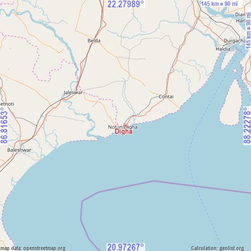
Digha GPS coordinates[2]
21° 37' 39.936" North, 87° 31' 10.74" East
| Map corner | latitude | longitude |
|---|---|---|
| Upper-left | 22.27989°, | 86.81653° |
| Center: | 21.62776°, | 87.51965° |
| Lower-right: | 20.97267°, | 88.22278° |
| Map W x H: | 145.3×145.4 km | = 90.3×90.3mi |
| max Lat: | 34.9274° ⇑58.5% North |
| Digha: | 21.62776° |
| min Lat: | ⇓41.5% South 8.09008° |
| min Long | Digha | max Long |
| 68.82655° | 87.51965° | 96.81° |
| W 90.2%⇐ | ⇒9.8% E |
Elevation
Elevation of Digha is 8 m = 26 ft, and this is 287.6 m = 944 ft below average elevation for this country.
| Max E: |
3681 m = 12077 ft | 98.3% |
| Avg. | 295.6 m = 970 ft | |
| Digha | 8 m = 26 ft | |
Min E: |
1 m = 3 ft | 1.7% |
See also: India elevation on elevation.city.
Geographical zone
Digha is located in North Torrid zone (between Equator and Tropic of Cancer). Distance of this Northern Tropic circle is 201.1 km =125 mi to North.| Distance of | km | miles | from Digha |
|---|---|---|---|
| North Pole | 7602.3 | 4723.8 | to North |
| Arctic Circle | 4996.4 | 3104.6 | to North |
| Tropic Cancer | 201.1 | 125 | to North |
| Equator | 2404.8 | 1494.3 | to South |


Nearby cities:
15 places around Digha: (largest is in red/bold)
• Balasore
62.4 km =38.8 mi,  256°
256°
• Bāli Chak
82 km =51 mi,  2°
2°
• Contai
29.1 km =18.1 mi,  54°
54°
• Egra
30.3 km =18.8 mi, 3°
• Haldia
77.6 km =48.2 mi, 51°
• Jaleshwar
36.3 km =22.6 mi,  302°
302°
• Kalaīkunda
84.7 km =52.6 mi,  339°
339°
• Kharagpur
81.7 km =50.8 mi,  345°
345°
• Mahīshādal
78.2 km =48.6 mi,  37°
37°
• Medinīpur
90.5 km =56.2 mi, 347°
• Monoharpur
78.6 km =48.8 mi, 47°
• Nīlgiri
79.9 km =49.6 mi, 256°
• Remuna
67.9 km =42.2 mi, 260°
• Solap
86.2 km =53.6 mi, 49°
• Tamlūk
85.8 km =53.3 mi,  29°
29°
Sources, notices
• [Note1] Compared only with cities in India existing in our database
• [Src1] Map data: © OpenStreetMap contributors (CC-BY-SA)
• [Src2] Other city data from geonames.org with taken over terms of usage.
• [Src3] Geographical zone / Annual Mean Temperature by Robert A. Rohde @ Wikipedia
