Remuna geodata
Remuna (Odisha) is a populated place; located in India in Asia/Kolkata (GMT+5.5) time zone. With population of 30,319 people, there are 1429 cities with bigger population in this country. Compared to other cities in India, 58.8% of cities are located further ↑North; 89% of cities are located further ←West and 86.8% of cities have higher elevation than Remuna. Note1


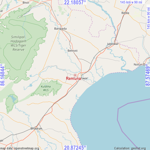
Remuna GPS coordinates[2]
21° 31' 40.728" North, 86° 52' 17.616" East
| Map corner | latitude | longitude |
|---|---|---|
| Upper-left | 22.18057°, | 86.16844° |
| Center: | 21.52798°, | 86.87156° |
| Lower-right: | 20.87245°, | 87.57469° |
| Map W x H: | 145.4×145.5 km | = 90.3×90.4mi |
| max Lat: | 34.9274° ⇑58.8% North |
| Remuna: | 21.52798° |
| min Lat: | ⇓41.2% South 8.09008° |
| min Long | Remuna | max Long |
| 68.82655° | 86.87156° | 96.81° |
| W 89%⇐ | ⇒11% E |
Elevation
Elevation of Remuna is 25 m = 82 ft, and this is 270.6 m = 888 ft below average elevation for this country.
| Max E: |
3681 m = 12077 ft | 86.8% |
| Avg. | 295.6 m = 970 ft | |
| Remuna | 25 m = 82 ft | |
Min E: |
1 m = 3 ft | 13.2% |
See also: India elevation on elevation.city.
Geographical zone
Remuna is located in North Torrid zone (between Equator and Tropic of Cancer). Distance of this Northern Tropic circle is 212.2 km =131.9 mi to North.| Distance of | km | miles | from Remuna |
|---|---|---|---|
| North Pole | 7613.4 | 4730.7 | to North |
| Arctic Circle | 5007.5 | 3111.5 | to North |
| Tropic Cancer | 212.2 | 131.9 | to North |
| Equator | 2393.7 | 1487.4 | to South |


Nearby cities:
15 places around Remuna: (largest is in red/bold)
• Balasore
7.5 km =4.7 mi,  121°
121°
• Bhadrakh
64.3 km =40 mi,  215°
215°
• Bāsudebpur
47.7 km =29.6 mi,  198°
198°
• Chākuliā
107.4 km =66.7 mi,  351°
351°
• Chāndbāli
84.8 km =52.7 mi,  189°
189°
• Contai
94.9 km =59 mi,  72°
72°
• Digha
67.9 km =42.2 mi,  80°
80°
• Egra
80.3 km =49.9 mi,  59°
59°
• Jaleshwar
47.3 km =29.4 mi,  49°
49°
• Jhārgrām
103.7 km =64.4 mi,  7°
7°
• Jājpur
93.7 km =58.2 mi, 216°
• Kalaīkunda
97.4 km =60.5 mi,  22°
22°
• Kharagpur
101.7 km =63.2 mi,  27°
27°
• Nīlgiri
13 km =8.1 mi,  235°
235°
• Soro
33.6 km =20.9 mi,  214°
214°
Sources, notices
• [Note1] Compared only with cities in India existing in our database
• [Src1] Map data: © OpenStreetMap contributors (CC-BY-SA)
• [Src2] Other city data from geonames.org with taken over terms of usage.
• [Src3] Geographical zone / Annual Mean Temperature by Robert A. Rohde @ Wikipedia
