Rājgarh geodata
Rājgarh (Madhya Pradesh) is a populated place; located in India in Asia/Kolkata (GMT+5.5) time zone. With population of 17,113 people, there are 2273 cities with bigger population in this country. Compared to other cities in India, 51.2% of cities are located further ↑North; 83.2% of cities are located further →East and 83.6% of cities have lower elevation than Rājgarh. Note1


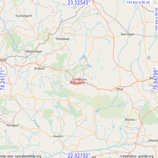
Rājgarh GPS coordinates[2]
22° 40' 41.556" North, 74° 56' 41.388" East
| Map corner | latitude | longitude |
|---|---|---|
| Upper-left | 23.32543°, | 74.24171° |
| Center: | 22.67821°, | 74.94483° |
| Lower-right: | 22.02792°, | 75.64796° |
| Map W x H: | 144.3×144.3 km | = 89.7×89.7mi |
| max Lat: | 34.9274° ⇑51.2% North |
| Rājgarh: | 22.67821° |
| min Lat: | ⇓48.8% South 8.09008° |
| min Long | Rājgarh | max Long |
| 68.82655° | 74.94483° | 96.81° |
| W 16.8%⇐ | ⇒83.2% E |
Elevation
Elevation of Rājgarh is 518 m = 1699 ft, and this is 222.4 m = 730 ft above average elevation for this country.
| Max E: |
3681 m = 12077 ft | 16.4% |
| Rājgarh | 518 m 1699 ft | |
| Avg. | 295.6 m = 970 ft | |
Min E: |
1 m = 3 ft | 83.6% |
See also: India elevation on elevation.city.
Geographical zone
Rājgarh is located in North Torrid zone (between Equator and Tropic of Cancer). Distance of this Northern Tropic circle is 84.3 km =52.4 mi to North.| Distance of | km | miles | from Rājgarh |
|---|---|---|---|
| North Pole | 7485.5 | 4651.3 | to North |
| Arctic Circle | 4879.6 | 3032 | to North |
| Tropic Cancer | 84.3 | 52.4 | to North |
| Equator | 2521.6 | 1566.8 | to South |


Nearby cities:
15 places around Rājgarh: (largest is in red/bold)
• Badnāwar
48.3 km =30 mi,  37°
37°
• Bamna
50 km =31.1 mi,  337°
337°
• Betma
68.7 km =42.7 mi,  89°
89°
• Bhābhra
65.4 km =40.6 mi,  255°
255°
• Bāg
38.9 km =24.2 mi,  204°
204°
• Depālpur
64.2 km =39.9 mi,  72°
72°
• Dhār
37.4 km =23.2 mi,  104°
104°
• Gautampura
68.1 km =42.3 mi,  59°
59°
• Jhābua
37.6 km =23.4 mi,  285°
285°
• Jobat
48.4 km =30.1 mi,  232°
232°
• Kukshi
55.8 km =34.7 mi, 200°
• Manāwar
51.4 km =31.9 mi,  163°
163°
• Petlāwad
40 km =24.9 mi, 337°
• Rānāpur
43.6 km =27.1 mi,  265°
265°
• Thandla
52.7 km =32.7 mi,  314°
314°
Sources, notices
• [Note1] Compared only with cities in India existing in our database
• [Src1] Map data: © OpenStreetMap contributors (CC-BY-SA)
• [Src2] Other city data from geonames.org with taken over terms of usage.
• [Src3] Geographical zone / Annual Mean Temperature by Robert A. Rohde @ Wikipedia
