Debīpur geodata
Debīpur (West Bengal) is a populated place; located in India in Asia/Kolkata (GMT+5.5) time zone. With population of 9,613 people, there are 2984 cities with bigger population in this country. Compared to other cities in India, 59.2% of cities are located further ↓South; 94.6% of cities are located further ←West and 88.1% of cities have higher elevation than Debīpur. Note1


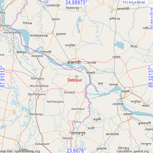
Debīpur GPS coordinates[2]
24° 15' 1.044" North, 88° 37' 5.664" East
| Map corner | latitude | longitude |
|---|---|---|
| Upper-left | 24.88975°, | 87.91512° |
| Center: | 24.25029°, | 88.61824° |
| Lower-right: | 23.6076°, | 89.32137° |
| Map W x H: | 142.6×142.6 km | = 88.6×88.6mi |
| max Lat: | 34.9274° ⇑40.8% North |
| Debīpur: | 24.25029° |
| min Lat: | ⇓59.2% South 8.09008° |
| min Long | Debīpur | max Long |
| 68.82655° | 88.61824° | 96.81° |
| W 94.6%⇐ | ⇒5.4% E |
Elevation
Elevation of Debīpur is 22 m = 72 ft, and this is 273.6 m = 898 ft below average elevation for this country.
| Max E: |
3681 m = 12077 ft | 88.1% |
| Avg. | 295.6 m = 970 ft | |
| Debīpur | 22 m = 72 ft | |
Min E: |
1 m = 3 ft | 11.9% |
See also: India elevation on elevation.city.
Geographical zone
Debīpur is located in North temperate zone (between Tropic of Cancer and the Arctic Circle). Distance of this Northern Tropic circle is 90.5 km =56.2 mi to South.| Distance of | km | miles | from Debīpur |
|---|---|---|---|
| North Pole | 7310.7 | 4542.7 | to North |
| Arctic Circle | 4704.8 | 2923.4 | to North |
| Tropic Cancer | 90.5 | 56.2 | to South |
| Equator | 2696.4 | 1675.5 | to South |


Nearby cities:
15 places around Debīpur: (largest is in red/bold)
• Baharampur
40.6 km =25.2 mi,  246°
246°
• Beldānga
50.6 km =31.4 mi,  225°
225°
• Dhuliān
82.6 km =51.3 mi,  305°
305°
• Jangipur
60.1 km =37.3 mi,  294°
294°
• Karīmpur
30.5 km =19 mi,  179°
179°
• Kāndi
67 km =41.6 mi,  241°
241°
• Kātoya
83.4 km =51.8 mi,  216°
216°
• Lālgola
41.7 km =25.9 mi,  297°
297°
• Muragācha
82.6 km =51.3 mi,  196°
196°
• Murshidābād
35.9 km =22.3 mi,  258°
258°
• Nalhāti
80.2 km =49.8 mi,  273°
273°
• Paikpara
91.2 km =56.7 mi, 309°
• Pakur
89.7 km =55.7 mi, 298°
• Pātuli
85.5 km =53.1 mi, 204°
• Rampur Hat
85.1 km =52.9 mi, 264°
Sources, notices
• [Note1] Compared only with cities in India existing in our database
• [Src1] Map data: © OpenStreetMap contributors (CC-BY-SA)
• [Src2] Other city data from geonames.org with taken over terms of usage.
• [Src3] Geographical zone / Annual Mean Temperature by Robert A. Rohde @ Wikipedia
