Murshidābād geodata
Murshidābād (West Bengal) is a populated place; located in India in Asia/Kolkata (GMT+5.5) time zone. With population of 39,557 people, there are 1118 cities with bigger population in this country. Compared to other cities in India, 58.9% of cities are located further ↓South; 92.6% of cities are located further ←West and 86.8% of cities have higher elevation than Murshidābād. Note1


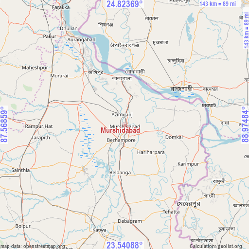
Murshidābād GPS coordinates[2]
24° 11' 2.04" North, 88° 16' 18.156" East
| Map corner | latitude | longitude |
|---|---|---|
| Upper-left | 24.82369°, | 87.56859° |
| Center: | 24.1839°, | 88.27171° |
| Lower-right: | 23.54088°, | 88.97484° |
| Map W x H: | 142.6×142.6 km | = 88.6×88.6mi |
| max Lat: | 34.9274° ⇑41.1% North |
| Murshidābād: | 24.1839° |
| min Lat: | ⇓58.9% South 8.09008° |
| min Long | Murshidābād | max Long |
| 68.82655° | 88.27171° | 96.81° |
| W 92.6%⇐ | ⇒7.4% E |
Elevation
Elevation of Murshidābād is 25 m = 82 ft, and this is 270.6 m = 888 ft below average elevation for this country.
| Max E: |
3681 m = 12077 ft | 86.8% |
| Avg. | 295.6 m = 970 ft | |
| Murshidābād | 25 m = 82 ft | |
Min E: |
1 m = 3 ft | 13.2% |
See also: India elevation on elevation.city.
Geographical zone
Murshidābād is located in North temperate zone (between Tropic of Cancer and the Arctic Circle). Distance of this Northern Tropic circle is 83.1 km =51.6 mi to South.| Distance of | km | miles | from Murshidābād |
|---|---|---|---|
| North Pole | 7318.1 | 4547.3 | to North |
| Arctic Circle | 4712.2 | 2928 | to North |
| Tropic Cancer | 83.1 | 51.6 | to South |
| Equator | 2689 | 1670.9 | to South |


Nearby cities:
15 places around Murshidābād: (largest is in red/bold)
• Ahmadpur
71.3 km =44.3 mi,  236°
236°
• Baharampur
9 km =5.6 mi,  193°
193°
• Beldānga
27.8 km =17.3 mi,  182°
182°
• Debīpur
35.9 km =22.3 mi,  78°
78°
• Dhuliān
64 km =39.8 mi,  329°
329°
• Jangipur
37.5 km =23.3 mi, 328°
• Karīmpur
42.2 km =26.2 mi,  123°
123°
• Kāndi
34.3 km =21.3 mi,  223°
223°
• Kātoya
61.5 km =38.2 mi, 193°
• Lālgola
26.6 km =16.5 mi,  355°
355°
• Nalhāti
46.6 km =29 mi,  285°
285°
• Pakur
66.7 km =41.4 mi,  319°
319°
• Pātuli
70.2 km =43.6 mi, 180°
• Rampur Hat
49.6 km =30.8 mi,  269°
269°
• Sainthia
65.5 km =40.7 mi,  246°
246°
Sources, notices
• [Note1] Compared only with cities in India existing in our database
• [Src1] Map data: © OpenStreetMap contributors (CC-BY-SA)
• [Src2] Other city data from geonames.org with taken over terms of usage.
• [Src3] Geographical zone / Annual Mean Temperature by Robert A. Rohde @ Wikipedia
