Pakur geodata
Pakur (Jharkhand) is a populated place; located in India in Asia/Kolkata (GMT+5.5) time zone. With population of 45,840 people, there are 964 cities with bigger population in this country. Compared to other cities in India, 61.5% of cities are located further ↓South; 90.9% of cities are located further ←West and 80.2% of cities have higher elevation than Pakur. Note1


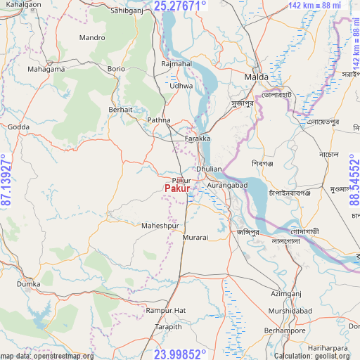
Pakur GPS coordinates[2]
24° 38' 21.3" North, 87° 50' 32.604" East
| Map corner | latitude | longitude |
|---|---|---|
| Upper-left | 25.27671°, | 87.13927° |
| Center: | 24.63925°, | 87.84239° |
| Lower-right: | 23.99852°, | 88.54552° |
| Map W x H: | 142.1×142.1 km | = 88.3×88.3mi |
| max Lat: | 34.9274° ⇑38.5% North |
| Pakur: | 24.63925° |
| min Lat: | ⇓61.5% South 8.09008° |
| min Long | Pakur | max Long |
| 68.82655° | 87.84239° | 96.81° |
| W 90.9%⇐ | ⇒9.1% E |
Elevation
Elevation of Pakur is 47 m = 154 ft, and this is 248.6 m = 816 ft below average elevation for this country.
| Max E: |
3681 m = 12077 ft | 80.2% |
| Avg. | 295.6 m = 970 ft | |
| Pakur | 47 m = 154 ft | |
Min E: |
1 m = 3 ft | 19.8% |
See also: Pakur elevation on elevation.city.
Geographical zone
Pakur is located in North temperate zone (between Tropic of Cancer and the Arctic Circle). Distance of this Northern Tropic circle is 133.7 km =83.1 mi to South.| Distance of | km | miles | from Pakur |
|---|---|---|---|
| North Pole | 7267.4 | 4515.8 | to North |
| Arctic Circle | 4661.5 | 2896.5 | to North |
| Tropic Cancer | 133.7 | 83.1 | to South |
| Equator | 2739.6 | 1702.3 | to South |


Nearby cities:
15 places around Pakur: (largest is in red/bold)
• Baharampur
72.5 km =45 mi,  145°
145°
• Dhuliān
12.2 km =7.6 mi,  67°
67°
• Dumka
72.9 km =45.3 mi,  235°
235°
• Farakka
20.6 km =12.8 mi,  16°
16°
• Godda
67 km =41.6 mi,  288°
288°
• Ingrāj Bāzār
50.9 km =31.6 mi,  37°
37°
• Jangipur
30.3 km =18.8 mi,  128°
128°
• Kāndi
78.2 km =48.6 mi,  165°
165°
• Lālgola
48 km =29.8 mi,  120°
120°
• Murshidābād
66.7 km =41.4 mi,  139°
139°
• Nalhāti
38.1 km =23.7 mi,  182°
182°
• Paikpara
16.8 km =10.4 mi,  28°
28°
• Rampur Hat
51.7 km =32.1 mi,  186°
186°
• Rājmahal
46 km =28.6 mi,  358°
358°
• Sāhibganj
70.4 km =43.7 mi,  342°
342°
Sources, notices
• [Note1] Compared only with cities in India existing in our database
• [Src1] Map data: © OpenStreetMap contributors (CC-BY-SA)
• [Src2] Other city data from geonames.org with taken over terms of usage.
• [Src3] Geographical zone / Annual Mean Temperature by Robert A. Rohde @ Wikipedia
