Paikpara geodata
Paikpara (West Bengal) is a populated place; located in India in Asia/Kolkata (GMT+5.5) time zone. With population of 2,000 people, there are 3431 cities with bigger population in this country. Compared to other cities in India, 62.2% of cities are located further ↓South; 91% of cities are located further ←West and 85.5% of cities have higher elevation than Paikpara. Note1


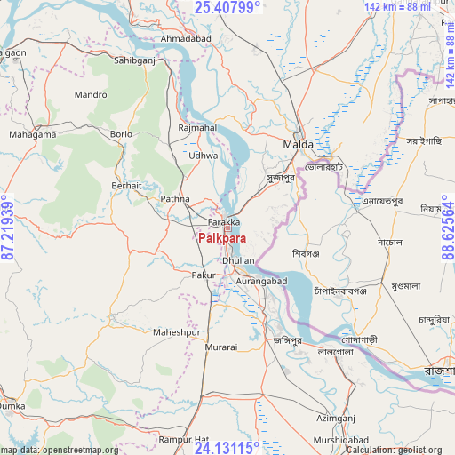
Paikpara GPS coordinates[2]
24° 46' 16.356" North, 87° 55' 21.036" East
| Map corner | latitude | longitude |
|---|---|---|
| Upper-left | 25.40799°, | 87.21939° |
| Center: | 24.77121°, | 87.92251° |
| Lower-right: | 24.13115°, | 88.62564° |
| Map W x H: | 142×142 km | = 88.2×88.2mi |
| max Lat: | 34.9274° ⇑37.8% North |
| Paikpara: | 24.77121° |
| min Lat: | ⇓62.2% South 8.09008° |
| min Long | Paikpara | max Long |
| 68.82655° | 87.92251° | 96.81° |
| W 91%⇐ | ⇒9% E |
Elevation
Elevation of Paikpara is 29 m = 95 ft, and this is 266.6 m = 875 ft below average elevation for this country.
| Max E: |
3681 m = 12077 ft | 85.5% |
| Avg. | 295.6 m = 970 ft | |
| Paikpara | 29 m = 95 ft | |
Min E: |
1 m = 3 ft | 14.5% |
See also: India elevation on elevation.city.
Geographical zone
Paikpara is located in North temperate zone (between Tropic of Cancer and the Arctic Circle). Distance of this Northern Tropic circle is 148.4 km =92.2 mi to South.| Distance of | km | miles | from Paikpara |
|---|---|---|---|
| North Pole | 7252.8 | 4506.7 | to North |
| Arctic Circle | 4646.9 | 2887.4 | to North |
| Tropic Cancer | 148.4 | 92.2 | to South |
| Equator | 2754.3 | 1711.4 | to South |


Nearby cities:
15 places around Paikpara: (largest is in red/bold)
• Baharampur
81.2 km =50.5 mi,  155°
155°
• Daulatpur
74.1 km =46 mi,  33°
33°
• Dhuliān
10.5 km =6.5 mi, 162°
• Farakka
5.5 km =3.4 mi,  335°
335°
• Godda
71.9 km =44.7 mi,  274°
274°
• Ingrāj Bāzār
34.3 km =21.3 mi,  40°
40°
• Jangipur
36.9 km =22.9 mi, 155°
• Lālgola
51.1 km =31.8 mi,  139°
139°
• Manihāri
70.1 km =43.6 mi,  334°
334°
• Murshidābād
74.3 km =46.2 mi,  151°
151°
• Nalhāti
53.6 km =33.3 mi,  190°
190°
• Pakur
16.8 km =10.4 mi,  208°
208°
• Rampur Hat
67.5 km =41.9 mi, 192°
• Rājmahal
32.7 km =20.3 mi, 343°
• Sāhibganj
60.1 km =37.3 mi, 331°
Sources, notices
• [Note1] Compared only with cities in India existing in our database
• [Src1] Map data: © OpenStreetMap contributors (CC-BY-SA)
• [Src2] Other city data from geonames.org with taken over terms of usage.
• [Src3] Geographical zone / Annual Mean Temperature by Robert A. Rohde @ Wikipedia
