Rampur Hat geodata
Rampur Hat (West Bengal) is a populated place; located in India in Asia/Kolkata (GMT+5.5) time zone. With population of 53,468 people, there are 829 cities with bigger population in this country. Compared to other cities in India, 58.9% of cities are located further ↓South; 90.7% of cities are located further ←West and 81.7% of cities have higher elevation than Rampur Hat. Note1


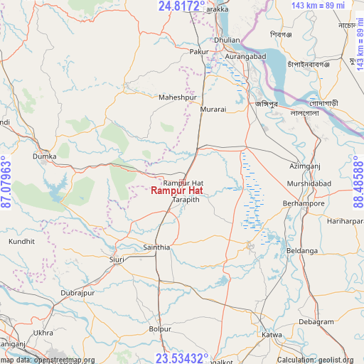
Rampur Hat GPS coordinates[2]
24° 10' 38.532" North, 87° 46' 57.9" East
| Map corner | latitude | longitude |
|---|---|---|
| Upper-left | 24.8172°, | 87.07963° |
| Center: | 24.17737°, | 87.78275° |
| Lower-right: | 23.53432°, | 88.48588° |
| Map W x H: | 142.6×142.6 km | = 88.6×88.6mi |
| max Lat: | 34.9274° ⇑41.1% North |
| Rampur Hat: | 24.17737° |
| min Lat: | ⇓58.9% South 8.09008° |
| min Long | Rampur Hat | max Long |
| 68.82655° | 87.78275° | 96.81° |
| W 90.7%⇐ | ⇒9.3% E |
Elevation
Elevation of Rampur Hat is 42 m = 138 ft, and this is 253.6 m = 832 ft below average elevation for this country.
| Max E: |
3681 m = 12077 ft | 81.7% |
| Avg. | 295.6 m = 970 ft | |
| Rampur Hat | 42 m = 138 ft | |
Min E: |
1 m = 3 ft | 18.3% |
See also: Rampur Hat elevation on elevation.city.
Geographical zone
Rampur Hat is located in North temperate zone (between Tropic of Cancer and the Arctic Circle). Distance of this Northern Tropic circle is 82.4 km =51.2 mi to South.| Distance of | km | miles | from Rampur Hat |
|---|---|---|---|
| North Pole | 7318.8 | 4547.7 | to North |
| Arctic Circle | 4712.9 | 2928.5 | to North |
| Tropic Cancer | 82.4 | 51.2 | to South |
| Equator | 2688.3 | 1670.4 | to South |


Nearby cities:
15 places around Rampur Hat: (largest is in red/bold)
• Ahmadpur
39.8 km =24.7 mi,  194°
194°
• Baharampur
48.2 km =30 mi,  99°
99°
• Bakreswar
53 km =32.9 mi,  231°
231°
• Beldānga
55.5 km =34.5 mi,  119°
119°
• Bolpur
57.9 km =36 mi, 188°
• Dhuliān
58.6 km =36.4 mi,  17°
17°
• Dumka
55.1 km =34.2 mi,  280°
280°
• Jangipur
44.1 km =27.4 mi,  42°
42°
• Kāndi
35.6 km =22.1 mi,  132°
132°
• Lālgola
54.8 km =34.1 mi,  60°
60°
• Murshidābād
49.6 km =30.8 mi,  89°
89°
• Nalhāti
14.1 km =8.8 mi, 19°
• Pakur
51.7 km =32.1 mi,  6°
6°
• Sainthia
27.5 km =17.1 mi,  202°
202°
• Siuri
39.6 km =24.6 mi,  220°
220°
Sources, notices
• [Note1] Compared only with cities in India existing in our database
• [Src1] Map data: © OpenStreetMap contributors (CC-BY-SA)
• [Src2] Other city data from geonames.org with taken over terms of usage.
• [Src3] Geographical zone / Annual Mean Temperature by Robert A. Rohde @ Wikipedia
