Baharampur geodata
Baharampur (West Bengal) is a populated place; located in India in Asia/Kolkata (GMT+5.5) time zone. With population of 180,547 people, there are 236 cities with bigger population in this country. Compared to other cities in India, 58.6% of cities are located further ↓South; 92.3% of cities are located further ←West and 87.2% of cities have higher elevation than Baharampur. Note1


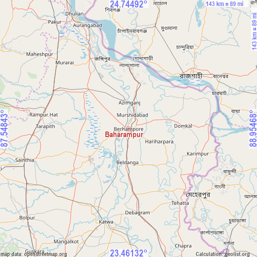
Baharampur GPS coordinates[2]
24° 6' 17.028" North, 88° 15' 5.58" East
| Map corner | latitude | longitude |
|---|---|---|
| Upper-left | 24.74492°, | 87.54843° |
| Center: | 24.10473°, | 88.25155° |
| Lower-right: | 23.46132°, | 88.95468° |
| Map W x H: | 142.7×142.7 km | = 88.7×88.7mi |
| max Lat: | 34.9274° ⇑41.4% North |
| Baharampur: | 24.10473° |
| min Lat: | ⇓58.6% South 8.09008° |
| min Long | Baharampur | max Long |
| 68.82655° | 88.25155° | 96.81° |
| W 92.3%⇐ | ⇒7.7% E |
Elevation
Elevation of Baharampur is 24 m = 79 ft, and this is 271.6 m = 891 ft below average elevation for this country.
| Max E: |
3681 m = 12077 ft | 87.2% |
| Avg. | 295.6 m = 970 ft | |
| Baharampur | 24 m = 79 ft | |
Min E: |
1 m = 3 ft | 12.8% |
See also: Baharampur elevation on elevation.city.
Geographical zone
Baharampur is located in North temperate zone (between Tropic of Cancer and the Arctic Circle). Distance of this Northern Tropic circle is 74.3 km =46.2 mi to South.| Distance of | km | miles | from Baharampur |
|---|---|---|---|
| North Pole | 7326.9 | 4552.7 | to North |
| Arctic Circle | 4721 | 2933.5 | to North |
| Tropic Cancer | 74.3 | 46.2 | to South |
| Equator | 2680.2 | 1665.4 | to South |


Nearby cities:
15 places around Baharampur: (largest is in red/bold)
• Ahmadpur
65 km =40.4 mi,  241°
241°
• Beldānga
19 km =11.8 mi,  177°
177°
• Debīpur
40.6 km =25.2 mi,  66°
66°
• Dhuliān
70.9 km =44.1 mi,  334°
334°
• Jangipur
44.3 km =27.5 mi,  336°
336°
• Karīmpur
40 km =24.9 mi,  110°
110°
• Kāndi
26.9 km =16.7 mi,  233°
233°
• Kātoya
52.5 km =32.6 mi,  193°
193°
• Lālgola
35.3 km =21.9 mi,  0°
0°
• Muragācha
64.8 km =40.3 mi,  167°
167°
• Murshidābād
9 km =5.6 mi,  13°
13°
• Nalhāti
47.9 km =29.8 mi,  296°
296°
• Pātuli
61.4 km =38.2 mi, 178°
• Rampur Hat
48.2 km =30 mi,  279°
279°
• Sainthia
60.6 km =37.7 mi,  253°
253°
Sources, notices
• [Note1] Compared only with cities in India existing in our database
• [Src1] Map data: © OpenStreetMap contributors (CC-BY-SA)
• [Src2] Other city data from geonames.org with taken over terms of usage.
• [Src3] Geographical zone / Annual Mean Temperature by Robert A. Rohde @ Wikipedia
