Khailār geodata
Khailār (Madhya Pradesh) is a populated place; located in India in Asia/Kolkata (GMT+5.5) time zone. With population of 13,334 people, there are 2626 cities with bigger population in this country. Compared to other cities in India, 65.6% of cities are located further ↓South; 54.5% of cities are located further ←West and 63% of cities have lower elevation than Khailār. Note1


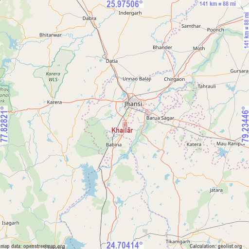
Khailār GPS coordinates[2]
25° 20' 28.572" North, 78° 31' 52.788" East
| Map corner | latitude | longitude |
|---|---|---|
| Upper-left | 25.97506°, | 77.82821° |
| Center: | 25.34127°, | 78.53133° |
| Lower-right: | 24.70414°, | 79.23446° |
| Map W x H: | 141.3×141.3 km | = 87.8×87.8mi |
| max Lat: | 34.9274° ⇑34.4% North |
| Khailār: | 25.34127° |
| min Lat: | ⇓65.6% South 8.09008° |
| min Long | Khailār | max Long |
| 68.82655° | 78.53133° | 96.81° |
| W 54.5%⇐ | ⇒45.5% E |
Elevation
Elevation of Khailār is 271 m = 889 ft, and this is 24.6 m = 81 ft below average elevation for this country.
| Max E: |
3681 m = 12077 ft | 37% |
| Avg. | 295.6 m = 970 ft | |
| Khailār | 271 m = 889 ft | |
Min E: |
1 m = 3 ft | 63% |
See also: India elevation on elevation.city.
Geographical zone
Khailār is located in North temperate zone (between Tropic of Cancer and the Arctic Circle). Distance of this Northern Tropic circle is 211.8 km =131.6 mi to South.| Distance of | km | miles | from Khailār |
|---|---|---|---|
| North Pole | 7189.4 | 4467.3 | to North |
| Arctic Circle | 4583.5 | 2848.1 | to North |
| Tropic Cancer | 211.8 | 131.6 | to South |
| Equator | 2817.7 | 1750.8 | to South |


Nearby cities:
15 places around Khailār: (largest is in red/bold)
• Babīna
12.9 km =8 mi,  208°
208°
• Barāgaon
23.5 km =14.6 mi,  50°
50°
• Bhānder
48.9 km =30.4 mi,  26°
26°
• Bāmor Kalān
62.9 km =39.1 mi,  217°
217°
• Chirgaon
38.3 km =23.8 mi, 47°
• Dabra
63.7 km =39.6 mi,  341°
341°
• Datia
37.6 km =23.4 mi,  348°
348°
• Jhānsi
14 km =8.7 mi,  20°
20°
• Karera
41.8 km =26 mi,  288°
288°
• Moth
60 km =37.3 mi,  44°
44°
• Orchha
11 km =6.8 mi,  83°
83°
• Pārīchha
29.5 km =18.3 mi, 51°
• Rānīpur
54.3 km =33.7 mi,  100°
100°
• Tori-Fatehpur
59.9 km =37.2 mi, 77°
• Tālbahat
34.5 km =21.4 mi,  196°
196°
Sources, notices
• [Note1] Compared only with cities in India existing in our database
• [Src1] Map data: © OpenStreetMap contributors (CC-BY-SA)
• [Src2] Other city data from geonames.org with taken over terms of usage.
• [Src3] Geographical zone / Annual Mean Temperature by Robert A. Rohde @ Wikipedia
