Tekanpur geodata
Tekanpur (Madhya Pradesh) is a populated place; located in India in Asia/Kolkata (GMT+5.5) time zone. With population of 13,681 people, there are 2592 cities with bigger population in this country. Compared to other cities in India, 70.3% of cities are located further ↓South; 52.1% of cities are located further ←West and 56.7% of cities have lower elevation than Tekanpur. Note1


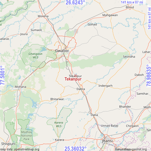
Tekanpur GPS coordinates[2]
25° 59' 38.436" North, 78° 16' 59.592" East
| Map corner | latitude | longitude |
|---|---|---|
| Upper-left | 26.6243°, | 77.5801° |
| Center: | 25.99401°, | 78.28322° |
| Lower-right: | 25.36032°, | 78.98635° |
| Map W x H: | 140.5×140.5 km | = 87.3×87.3mi |
| max Lat: | 34.9274° ⇑29.7% North |
| Tekanpur: | 25.99401° |
| min Lat: | ⇓70.3% South 8.09008° |
| min Long | Tekanpur | max Long |
| 68.82655° | 78.28322° | 96.81° |
| W 52.1%⇐ | ⇒47.9% E |
Elevation
Elevation of Tekanpur is 233 m = 764 ft, and this is 62.6 m = 205 ft below average elevation for this country.
| Max E: |
3681 m = 12077 ft | 43.3% |
| Avg. | 295.6 m = 970 ft | |
| Tekanpur | 233 m = 764 ft | |
Min E: |
1 m = 3 ft | 56.7% |
See also: India elevation on elevation.city.
Geographical zone
Tekanpur is located in North temperate zone (between Tropic of Cancer and the Arctic Circle). Distance of this Northern Tropic circle is 284.3 km =176.7 mi to South.| Distance of | km | miles | from Tekanpur |
|---|---|---|---|
| North Pole | 7116.8 | 4422.2 | to North |
| Arctic Circle | 4510.9 | 2802.9 | to North |
| Tropic Cancer | 284.3 | 176.7 | to South |
| Equator | 2890.3 | 1795.9 | to South |


Nearby cities:
15 places around Tekanpur: (largest is in red/bold)
• Alampur
51.5 km =32 mi,  86°
86°
• Antri
10.2 km =6.3 mi,  314°
314°
• Bhitarwār
28.3 km =17.6 mi,  217°
217°
• Bhānder
54.4 km =33.8 mi,  121°
121°
• Daboh
59.3 km =36.8 mi, 89°
• Dabra
13 km =8.1 mi,  157°
157°
• Datia
39.8 km =24.7 mi,  153°
153°
• Gohadi
51.3 km =31.9 mi,  17°
17°
• Gwalior
28.4 km =17.6 mi,  337°
337°
• Jora
61.1 km =38 mi, 309°
• Karera
61.4 km =38.2 mi,  193°
193°
• Mau
49.1 km =30.5 mi,  52°
52°
• Morār
26.5 km =16.5 mi,  347°
347°
• Narwar
53.8 km =33.4 mi, 223°
• Seondha
52.8 km =32.8 mi,  70°
70°
Sources, notices
• [Note1] Compared only with cities in India existing in our database
• [Src1] Map data: © OpenStreetMap contributors (CC-BY-SA)
• [Src2] Other city data from geonames.org with taken over terms of usage.
• [Src3] Geographical zone / Annual Mean Temperature by Robert A. Rohde @ Wikipedia
