Karera geodata
Karera (Madhya Pradesh) is a populated place; located in India in Asia/Kolkata (GMT+5.5) time zone. With population of 26,212 people, there are 1626 cities with bigger population in this country. Compared to other cities in India, 66.5% of cities are located further ↓South; 50.4% of cities are located further ←West and 64% of cities have lower elevation than Karera. Note1


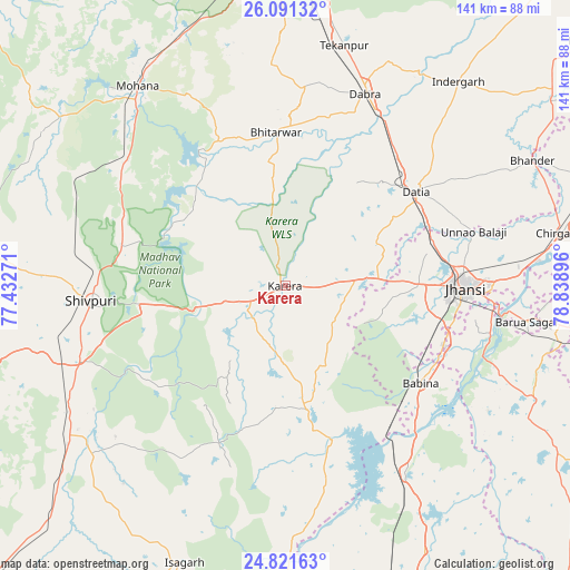
Karera GPS coordinates[2]
25° 27' 29.34" North, 78° 8' 8.988" East
| Map corner | latitude | longitude |
|---|---|---|
| Upper-left | 26.09132°, | 77.43271° |
| Center: | 25.45815°, | 78.13583° |
| Lower-right: | 24.82163°, | 78.83896° |
| Map W x H: | 141.2×141.2 km | = 87.7×87.7mi |
| max Lat: | 34.9274° ⇑33.5% North |
| Karera: | 25.45815° |
| min Lat: | ⇓66.5% South 8.09008° |
| min Long | Karera | max Long |
| 68.82655° | 78.13583° | 96.81° |
| W 50.4%⇐ | ⇒49.6% E |
Elevation
Elevation of Karera is 279 m = 915 ft, and this is 16.6 m = 54 ft below average elevation for this country.
| Max E: |
3681 m = 12077 ft | 36% |
| Avg. | 295.6 m = 970 ft | |
| Karera | 279 m = 915 ft | |
Min E: |
1 m = 3 ft | 64% |
See also: India elevation on elevation.city.
Geographical zone
Karera is located in North temperate zone (between Tropic of Cancer and the Arctic Circle). Distance of this Northern Tropic circle is 224.8 km =139.7 mi to South.| Distance of | km | miles | from Karera |
|---|---|---|---|
| North Pole | 7176.4 | 4459.2 | to North |
| Arctic Circle | 4570.5 | 2840 | to North |
| Tropic Cancer | 224.8 | 139.7 | to South |
| Equator | 2830.7 | 1758.9 | to South |


Nearby cities:
15 places around Karera: (largest is in red/bold)
• Babīna
41.5 km =25.8 mi,  125°
125°
• Barāgaon
57.9 km =36 mi,  88°
88°
• Bhitarwār
37.2 km =23.1 mi,  356°
356°
• Bāmor Kalān
62.9 km =39.1 mi,  178°
178°
• Dabra
51.5 km =32 mi,  22°
22°
• Datia
40.3 km =25 mi,  53°
53°
• Jhānsi
44.6 km =27.7 mi, 89°
• Khailār
41.8 km =26 mi,  108°
108°
• Kolāras
59 km =36.7 mi,  243°
243°
• Narwar
30.4 km =18.9 mi,  312°
312°
• Orchha
52 km =32.3 mi,  103°
103°
• Pārīchha
62.8 km =39 mi,  84°
84°
• Shivpuri
47.7 km =29.6 mi,  265°
265°
• Tekanpur
61.4 km =38.2 mi,  13°
13°
• Tālbahat
55 km =34.2 mi,  146°
146°
Sources, notices
• [Note1] Compared only with cities in India existing in our database
• [Src1] Map data: © OpenStreetMap contributors (CC-BY-SA)
• [Src2] Other city data from geonames.org with taken over terms of usage.
• [Src3] Geographical zone / Annual Mean Temperature by Robert A. Rohde @ Wikipedia
