Dabra geodata
Dabra (Madhya Pradesh) is a populated place; located in India in Asia/Kolkata (GMT+5.5) time zone. With population of 60,836 people, there are 720 cities with bigger population in this country. Compared to other cities in India, 69.6% of cities are located further ↓South; 52.5% of cities are located further ←West and 50.9% of cities have lower elevation than Dabra. Note1


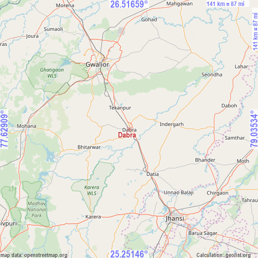
Dabra GPS coordinates[2]
25° 53' 8.592" North, 78° 19' 55.956" East
| Map corner | latitude | longitude |
|---|---|---|
| Upper-left | 26.51659°, | 77.62909° |
| Center: | 25.88572°, | 78.33221° |
| Lower-right: | 25.25146°, | 79.03534° |
| Map W x H: | 140.7×140.7 km | = 87.4×87.4mi |
| max Lat: | 34.9274° ⇑30.4% North |
| Dabra: | 25.88572° |
| min Lat: | ⇓69.6% South 8.09008° |
| min Long | Dabra | max Long |
| 68.82655° | 78.33221° | 96.81° |
| W 52.5%⇐ | ⇒47.5% E |
Elevation
Elevation of Dabra is 207 m = 679 ft, and this is 88.6 m = 291 ft below average elevation for this country.
| Max E: |
3681 m = 12077 ft | 49.1% |
| Avg. | 295.6 m = 970 ft | |
| Dabra | 207 m = 679 ft | |
Min E: |
1 m = 3 ft | 50.9% |
See also: Dabra elevation on elevation.city.
Geographical zone
Dabra is located in North temperate zone (between Tropic of Cancer and the Arctic Circle). Distance of this Northern Tropic circle is 272.3 km =169.2 mi to South.| Distance of | km | miles | from Dabra |
|---|---|---|---|
| North Pole | 7128.8 | 4429.6 | to North |
| Arctic Circle | 4523 | 2810.5 | to North |
| Tropic Cancer | 272.3 | 169.2 | to South |
| Equator | 2878.2 | 1788.4 | to South |


Nearby cities:
15 places around Dabra: (largest is in red/bold)
• Alampur
49 km =30.4 mi,  71°
71°
• Antri
22.7 km =14.1 mi,  327°
327°
• Bhitarwār
24.5 km =15.2 mi,  244°
244°
• Bhānder
44.6 km =27.7 mi,  111°
111°
• Daboh
56 km =34.8 mi,  76°
76°
• Datia
26.8 km =16.7 mi,  151°
151°
• Gwalior
41.4 km =25.7 mi,  337°
337°
• Jhānsi
53.6 km =33.3 mi, 152°
• Karera
51.5 km =32 mi,  202°
202°
• Mau
54.1 km =33.6 mi,  38°
38°
• Morār
39.4 km =24.5 mi, 344°
• Narwar
49.9 km =31 mi, 237°
• Samthar
57.7 km =35.9 mi,  94°
94°
• Seondha
53.9 km =33.5 mi,  56°
56°
• Tekanpur
13 km =8.1 mi, 337°
Sources, notices
• [Note1] Compared only with cities in India existing in our database
• [Src1] Map data: © OpenStreetMap contributors (CC-BY-SA)
• [Src2] Other city data from geonames.org with taken over terms of usage.
• [Src3] Geographical zone / Annual Mean Temperature by Robert A. Rohde @ Wikipedia
