Dandeli geodata
Dandeli (Karnataka) is a populated place; located in India in Asia/Kolkata (GMT+5.5) time zone. With population of 52,295 people, there are 856 cities with bigger population in this country. Compared to other cities in India, 80.9% of cities are located further ↑North; 85.9% of cities are located further →East and 81.1% of cities have lower elevation than Dandeli. Note1


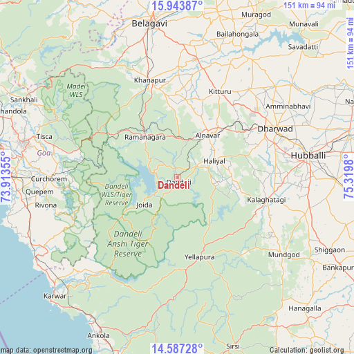
Dandeli GPS coordinates[2]
15° 16' 0.012" North, 74° 37' 0.012" East
| Map corner | latitude | longitude |
|---|---|---|
| Upper-left | 15.94387°, | 73.91355° |
| Center: | 15.26667°, | 74.61667° |
| Lower-right: | 14.58728°, | 75.3198° |
| Map W x H: | 150.8×150.8 km | = 93.7×93.7mi |
| max Lat: | 34.9274° ⇑80.9% North |
| Dandeli: | 15.26667° |
| min Lat: | ⇓19.1% South 8.09008° |
| min Long | Dandeli | max Long |
| 68.82655° | 74.61667° | 96.81° |
| W 14.1%⇐ | ⇒85.9% E |
Elevation
Elevation of Dandeli is 474 m = 1555 ft, and this is 178.4 m = 585 ft above average elevation for this country.
| Max E: |
3681 m = 12077 ft | 18.9% |
| Dandeli | 474 m 1555 ft | |
| Avg. | 295.6 m = 970 ft | |
Min E: |
1 m = 3 ft | 81.1% |
See also: Dandeli elevation on elevation.city.
Geographical zone
Dandeli is located in North Torrid zone (between Equator and Tropic of Cancer). Distance of this Northern Tropic circle is 908.4 km =564.5 mi to North.| Distance of | km | miles | from Dandeli |
|---|---|---|---|
| North Pole | 8309.6 | 5163.3 | to North |
| Arctic Circle | 5703.7 | 3544.1 | to North |
| Tropic Cancer | 908.4 | 564.5 | to North |
| Equator | 1697.5 | 1054.8 | to South |


Nearby cities:
15 places around Dandeli: (largest is in red/bold)
• Alnāvar
22.3 km =13.9 mi,  36°
36°
• Bail-Hongal
66.1 km =41.1 mi,  23°
23°
• Curchorem
54.5 km =33.9 mi,  269°
269°
• Haliyal
16.5 km =10.3 mi,  65°
65°
• Hubli
56.2 km =34.9 mi,  80°
80°
• Kalghatgi
39.1 km =24.3 mi,  103°
103°
• Khānāpur
43.1 km =26.8 mi,  344°
344°
• Londa
24.8 km =15.4 mi, 335°
• Mundgod
55.8 km =34.7 mi,  126°
126°
• Palle
61.4 km =38.2 mi,  291°
291°
• Quepem
58.2 km =36.2 mi,  264°
264°
• Sanguem
50.1 km =31.1 mi, 265°
• Sanvordem
53.3 km =33.1 mi, 269°
• Valpoy
59.3 km =36.8 mi,  299°
299°
• Yellāpur
35.1 km =21.8 mi,  163°
163°
Sources, notices
• [Note1] Compared only with cities in India existing in our database
• [Src1] Map data: © OpenStreetMap contributors (CC-BY-SA)
• [Src2] Other city data from geonames.org with taken over terms of usage.
• [Src3] Geographical zone / Annual Mean Temperature by Robert A. Rohde @ Wikipedia
