Chikmagalūr geodata
Chikmagalūr (Karnataka) is a populated place; located in India in Asia/Kolkata (GMT+5.5) time zone. With population of 121,484 people, there are 364 cities with bigger population in this country. Compared to other cities in India, 84.9% of cities are located further ↑North; 76.1% of cities are located further →East and 96.4% of cities have lower elevation than Chikmagalūr. Note1


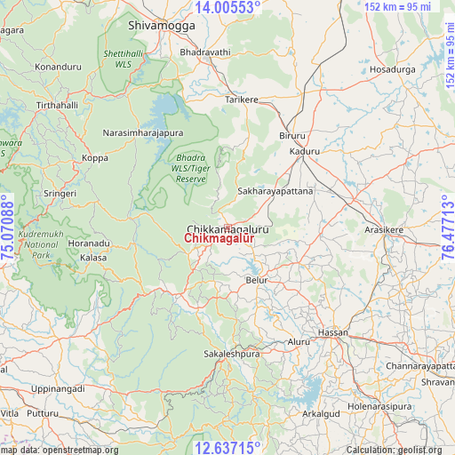
Chikmagalūr GPS coordinates[2]
13° 19' 20.316" North, 75° 46' 26.4" East
| Map corner | latitude | longitude |
|---|---|---|
| Upper-left | 14.00553°, | 75.07088° |
| Center: | 13.32231°, | 75.774° |
| Lower-right: | 12.63715°, | 76.47713° |
| Map W x H: | 152.1×152.2 km | = 94.5×94.6mi |
| max Lat: | 34.9274° ⇑84.9% North |
| Chikmagalūr: | 13.32231° |
| min Lat: | ⇓15.1% South 8.09008° |
| min Long | Chikmagalūr | max Long |
| 68.82655° | 75.774° | 96.81° |
| W 23.9%⇐ | ⇒76.1% E |
Elevation
Elevation of Chikmagalūr is 1042 m = 3419 ft, and this is 746.4 m = 2449 ft above average elevation for this country.
| Max E: |
3681 m = 12077 ft | 3.6% |
| Chikmagalūr | 1042 m 3419 ft | |
| Avg. | 295.6 m = 970 ft | |
Min E: |
1 m = 3 ft | 96.4% |
See also: Chikmagalūr elevation on elevation.city.
Geographical zone
Chikmagalūr is located in North Torrid zone (between Equator and Tropic of Cancer). Distance of this Northern Tropic circle is 1124.6 km =698.8 mi to North.| Distance of | km | miles | from Chikmagalūr |
|---|---|---|---|
| North Pole | 8525.8 | 5297.7 | to North |
| Arctic Circle | 5919.9 | 3678.5 | to North |
| Tropic Cancer | 1124.6 | 698.8 | to North |
| Equator | 1481.3 | 920.4 | to South |


Nearby cities:
15 places around Chikmagalūr: (largest is in red/bold)
• Ajjampur
51.6 km =32.1 mi,  29°
29°
• Alūr
44.9 km =27.9 mi,  148°
148°
• Arsikere
52.3 km =32.5 mi,  90°
90°
• Belūr
20 km =12.4 mi, 150°
• Bhadrāvati
59 km =36.7 mi,  352°
352°
• Birūr
37.3 km =23.2 mi, 34°
• Bānāvar
43.2 km =26.8 mi,  76°
76°
• Hassan
49.4 km =30.7 mi,  135°
135°
• Kadūr
36.3 km =22.6 mi,  45°
45°
• Koppa
50.1 km =31.1 mi,  297°
297°
• Mudgere
25.4 km =15.8 mi,  214°
214°
• Narasimharājapura
42.8 km =26.6 mi,  318°
318°
• Sakleshpur
42.4 km =26.3 mi,  178°
178°
• Sringeri
57.4 km =35.7 mi,  280°
280°
• Tarikere
43.3 km =26.9 mi,  5°
5°
Sources, notices
• [Note1] Compared only with cities in India existing in our database
• [Src1] Map data: © OpenStreetMap contributors (CC-BY-SA)
• [Src2] Other city data from geonames.org with taken over terms of usage.
• [Src3] Geographical zone / Annual Mean Temperature by Robert A. Rohde @ Wikipedia
