Bhadrāvati geodata
Bhadrāvati (Karnataka) is a populated place; located in India in Asia/Kolkata (GMT+5.5) time zone. With population of 163,903 people, there are 264 cities with bigger population in this country. Compared to other cities in India, 83.6% of cities are located further ↑North; 76.6% of cities are located further →East and 88% of cities have lower elevation than Bhadrāvati. Note1


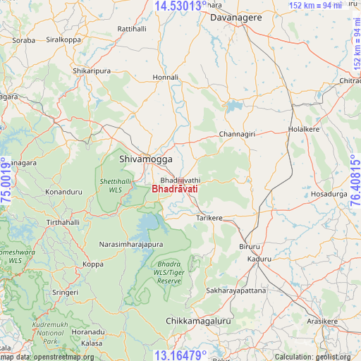
Bhadrāvati GPS coordinates[2]
13° 50' 54.456" North, 75° 42' 18.072" East
| Map corner | latitude | longitude |
|---|---|---|
| Upper-left | 14.53013°, | 75.0019° |
| Center: | 13.84846°, | 75.70502° |
| Lower-right: | 13.16479°, | 76.40815° |
| Map W x H: | 151.8×151.8 km | = 94.3×94.3mi |
| max Lat: | 34.9274° ⇑83.6% North |
| Bhadrāvati: | 13.84846° |
| min Lat: | ⇓16.4% South 8.09008° |
| min Long | Bhadrāvati | max Long |
| 68.82655° | 75.70502° | 96.81° |
| W 23.4%⇐ | ⇒76.6% E |
Elevation
Elevation of Bhadrāvati is 592 m = 1942 ft, and this is 296.4 m = 972 ft above average elevation for this country.
| Max E: |
3681 m = 12077 ft | 12% |
| Bhadrāvati | 592 m 1942 ft | |
| Avg. | 295.6 m = 970 ft | |
Min E: |
1 m = 3 ft | 88% |
See also: Bhadrāvati elevation on elevation.city.
Geographical zone
Bhadrāvati is located in North Torrid zone (between Equator and Tropic of Cancer). Distance of this Northern Tropic circle is 1066.1 km =662.4 mi to North.| Distance of | km | miles | from Bhadrāvati |
|---|---|---|---|
| North Pole | 8467.3 | 5261.3 | to North |
| Arctic Circle | 5861.4 | 3642.1 | to North |
| Tropic Cancer | 1066.1 | 662.4 | to North |
| Equator | 1539.8 | 956.8 | to South |


Nearby cities:
15 places around Bhadrāvati: (largest is in red/bold)
• Ajjampur
35.2 km =21.9 mi,  112°
112°
• Beltangadi
46.2 km =28.7 mi,  288°
288°
• Birūr
40.1 km =24.9 mi,  134°
134°
• Channagiri
30.8 km =19.1 mi,  50°
50°
• Chikmagalūr
59 km =36.7 mi,  172°
172°
• Holalkere
56.1 km =34.9 mi,  67°
67°
• Honnāli
44 km =27.3 mi,  351°
351°
• Kadūr
46.7 km =29 mi, 134°
• Koppa
51.1 km =31.8 mi,  226°
226°
• Kumsi
40.1 km =24.9 mi,  304°
304°
• Narasimharājapura
33.7 km =20.9 mi,  218°
218°
• Nyāmti
36.2 km =22.5 mi,  337°
337°
• Shimoga
17.4 km =10.8 mi, 301°
• Tarikere
19.4 km =12.1 mi,  142°
142°
• Tīrthahalli
52.7 km =32.7 mi,  250°
250°
Sources, notices
• [Note1] Compared only with cities in India existing in our database
• [Src1] Map data: © OpenStreetMap contributors (CC-BY-SA)
• [Src2] Other city data from geonames.org with taken over terms of usage.
• [Src3] Geographical zone / Annual Mean Temperature by Robert A. Rohde @ Wikipedia
