Mudgere geodata
Mudgere (Karnataka) is a populated place; located in India in Asia/Kolkata (GMT+5.5) time zone. With population of 9,322 people, there are 3010 cities with bigger population in this country. Compared to other cities in India, 85.6% of cities are located further ↑North; 77.1% of cities are located further →East and 96% of cities have lower elevation than Mudgere. Note1


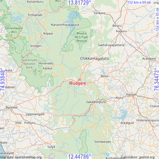
Mudgere GPS coordinates[2]
13° 8' 0.708" North, 75° 38' 29.76" East
| Map corner | latitude | longitude |
|---|---|---|
| Upper-left | 13.81729°, | 74.93848° |
| Center: | 13.13353°, | 75.6416° |
| Lower-right: | 12.44786°, | 76.34473° |
| Map W x H: | 152.3×152.3 km | = 94.6×94.6mi |
| max Lat: | 34.9274° ⇑85.6% North |
| Mudgere: | 13.13353° |
| min Lat: | ⇓14.4% South 8.09008° |
| min Long | Mudgere | max Long |
| 68.82655° | 75.6416° | 96.81° |
| W 22.9%⇐ | ⇒77.1% E |
Elevation
Elevation of Mudgere is 963 m = 3159 ft, and this is 667.4 m = 2190 ft above average elevation for this country.
| Max E: |
3681 m = 12077 ft | 4% |
| Mudgere | 963 m 3159 ft | |
| Avg. | 295.6 m = 970 ft | |
Min E: |
1 m = 3 ft | 96% |
See also: India elevation on elevation.city.
Geographical zone
Mudgere is located in North Torrid zone (between Equator and Tropic of Cancer). Distance of this Northern Tropic circle is 1145.6 km =711.8 mi to North.| Distance of | km | miles | from Mudgere |
|---|---|---|---|
| North Pole | 8546.8 | 5310.7 | to North |
| Arctic Circle | 5940.9 | 3691.5 | to North |
| Tropic Cancer | 1145.6 | 711.8 | to North |
| Equator | 1460.3 | 907.4 | to South |


Nearby cities:
15 places around Mudgere: (largest is in red/bold)
• Alūr
41.6 km =25.8 mi,  114°
114°
• Arkalgūd
61.4 km =38.2 mi,  132°
132°
• Belūr
24.5 km =15.2 mi,  81°
81°
• Birūr
62.7 km =39 mi,  34°
34°
• Chikmagalūr
25.4 km =15.8 mi, 34°
• Gorūr
57.4 km =35.7 mi, 126°
• Hassan
51.2 km =31.8 mi, 105°
• Kadūr
61.5 km =38.2 mi,  40°
40°
• Kodlipet
45.5 km =28.3 mi,  144°
144°
• Koppa
53.4 km =33.2 mi,  325°
325°
• Narasimharājapura
54.9 km =34.1 mi,  345°
345°
• Puttūr
63.2 km =39.3 mi,  228°
228°
• Sakleshpur
26.4 km =16.4 mi, 144°
• Sanivārsante
52.3 km =32.5 mi,  149°
149°
• Sringeri
52.6 km =32.7 mi,  306°
306°
Sources, notices
• [Note1] Compared only with cities in India existing in our database
• [Src1] Map data: © OpenStreetMap contributors (CC-BY-SA)
• [Src2] Other city data from geonames.org with taken over terms of usage.
• [Src3] Geographical zone / Annual Mean Temperature by Robert A. Rohde @ Wikipedia
