Simga geodata
Simga (Chhattisgarh) is a populated place; located in India in Asia/Kolkata (GMT+5.5) time zone. With population of 12,944 people, there are 2662 cities with bigger population in this country. Compared to other cities in India, 58.5% of cities are located further ↑North; 75.6% of cities are located further ←West and 62.8% of cities have lower elevation than Simga. Note1


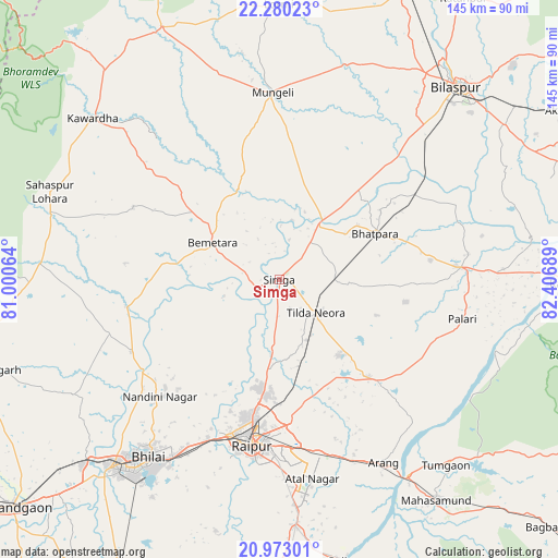
Simga GPS coordinates[2]
21° 37' 41.16" North, 81° 42' 13.536" East
| Map corner | latitude | longitude |
|---|---|---|
| Upper-left | 22.28023°, | 81.00064° |
| Center: | 21.6281°, | 81.70376° |
| Lower-right: | 20.97301°, | 82.40689° |
| Map W x H: | 145.3×145.4 km | = 90.3×90.3mi |
| max Lat: | 34.9274° ⇑58.5% North |
| Simga: | 21.6281° |
| min Lat: | ⇓41.5% South 8.09008° |
| min Long | Simga | max Long |
| 68.82655° | 81.70376° | 96.81° |
| W 75.6%⇐ | ⇒24.4% E |
Elevation
Elevation of Simga is 270 m = 886 ft, and this is 25.6 m = 84 ft below average elevation for this country.
| Max E: |
3681 m = 12077 ft | 37.2% |
| Avg. | 295.6 m = 970 ft | |
| Simga | 270 m = 886 ft | |
Min E: |
1 m = 3 ft | 62.8% |
See also: India elevation on elevation.city.
Geographical zone
Simga is located in North Torrid zone (between Equator and Tropic of Cancer). Distance of this Northern Tropic circle is 201.1 km =125 mi to North.| Distance of | km | miles | from Simga |
|---|---|---|---|
| North Pole | 7602.2 | 4723.8 | to North |
| Arctic Circle | 4996.4 | 3104.6 | to North |
| Tropic Cancer | 201.1 | 125 | to North |
| Equator | 2404.8 | 1494.3 | to South |


Nearby cities:
15 places around Simga: (largest is in red/bold)
• Arang
55.3 km =34.4 mi,  150°
150°
• Baloda Bāzār
47.3 km =29.4 mi,  86°
86°
• Bemetāra
20 km =12.4 mi,  299°
299°
• Bhatgaon
53.2 km =33.1 mi,  180°
180°
• Bhilai
54.6 km =33.9 mi,  211°
211°
• Bhātāpāra
27.8 km =17.3 mi,  64°
64°
• Bilāspur
68.5 km =42.6 mi,  42°
42°
• Durg
65.7 km =40.8 mi,  222°
222°
• Gandai
62.5 km =38.8 mi,  273°
273°
• Kawardha
64.5 km =40.1 mi,  310°
310°
• Kumhāri
44.6 km =27.7 mi, 205°
• Mungeli
48.7 km =30.3 mi,  357°
357°
• Pātan
68.4 km =42.5 mi,  194°
194°
• Raipur
44.5 km =27.7 mi, 189°
• Takhatpur
58.3 km =36.2 mi,  17°
17°
Sources, notices
• [Note1] Compared only with cities in India existing in our database
• [Src1] Map data: © OpenStreetMap contributors (CC-BY-SA)
• [Src2] Other city data from geonames.org with taken over terms of usage.
• [Src3] Geographical zone / Annual Mean Temperature by Robert A. Rohde @ Wikipedia
