Kawardha geodata
Kawardha (Chhattisgarh) is a seat of a second-order administrative division; located in India in Asia/Kolkata (GMT+5.5) time zone. With population of 35,238 people, there are 1233 cities with bigger population in this country. Compared to other cities in India, 56.7% of cities are located further ↑North; 73.7% of cities are located further ←West and 72.5% of cities have lower elevation than Kawardha. Note1


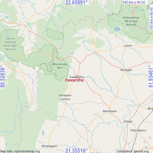
Kawardha GPS coordinates[2]
22° 0' 30.708" North, 81° 13' 53.328" East
| Map corner | latitude | longitude |
|---|---|---|
| Upper-left | 22.65891°, | 80.52836° |
| Center: | 22.00853°, | 81.23148° |
| Lower-right: | 21.35516°, | 81.93461° |
| Map W x H: | 145×145 km | = 90.1×90.1mi |
| max Lat: | 34.9274° ⇑56.7% North |
| Kawardha: | 22.00853° |
| min Lat: | ⇓43.3% South 8.09008° |
| min Long | Kawardha | max Long |
| 68.82655° | 81.23148° | 96.81° |
| W 73.7%⇐ | ⇒26.3% E |
Elevation
Elevation of Kawardha is 356 m = 1168 ft, and this is 60.4 m = 198 ft above average elevation for this country.
| Max E: |
3681 m = 12077 ft | 27.5% |
| Kawardha | 356 m 1168 ft | |
| Avg. | 295.6 m = 970 ft | |
Min E: |
1 m = 3 ft | 72.5% |
See also: India elevation on elevation.city.
Geographical zone
Kawardha is located in North Torrid zone (between Equator and Tropic of Cancer). Distance of this Northern Tropic circle is 158.8 km =98.7 mi to North.| Distance of | km | miles | from Kawardha |
|---|---|---|---|
| North Pole | 7559.9 | 4697.5 | to North |
| Arctic Circle | 4954.1 | 3078.3 | to North |
| Tropic Cancer | 158.8 | 98.7 | to North |
| Equator | 2447.1 | 1520.6 | to South |


Nearby cities:
15 places around Kawardha: (largest is in red/bold)
• Baihar
71 km =44.1 mi,  278°
278°
• Bemetāra
45.1 km =28 mi,  136°
136°
• Bhātāpāra
79.9 km =49.6 mi,  112°
112°
• Chhuīkhadān
59.1 km =36.7 mi,  204°
204°
• Gandai
40.4 km =25.1 mi, 199°
• Khairāgarh
70.6 km =43.9 mi, 201°
• Kotā
87.6 km =54.4 mi,  68°
68°
• Kumhāri
87.6 km =54.4 mi,  160°
160°
• Lormi
56.7 km =35.2 mi,  58°
58°
• Mungeli
47.2 km =29.3 mi,  82°
82°
• Pandaria
30.3 km =18.8 mi,  37°
37°
• Pāndātarai
22.2 km =13.8 mi,  26°
26°
• Simga
64.5 km =40.1 mi,  130°
130°
• Takhatpur
67.1 km =41.7 mi, 78°
• Ukwā
79 km =49.1 mi,  266°
266°
Sources, notices
• [Note1] Compared only with cities in India existing in our database
• [Src1] Map data: © OpenStreetMap contributors (CC-BY-SA)
• [Src2] Other city data from geonames.org with taken over terms of usage.
• [Src3] Geographical zone / Annual Mean Temperature by Robert A. Rohde @ Wikipedia
