Fatwa geodata
Fatwa (Bihar) is a populated place; located in India in Asia/Kolkata (GMT+5.5) time zone. With population of 41,647 people, there are 1061 cities with bigger population in this country. Compared to other cities in India, 66.9% of cities are located further ↓South; 85% of cities are located further ←West and 78% of cities have higher elevation than Fatwa. Note1


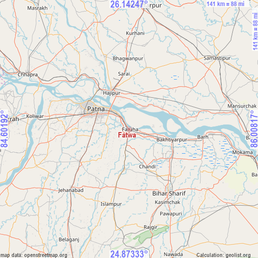
Fatwa GPS coordinates[2]
25° 30' 34.488" North, 85° 18' 18.144" East
| Map corner | latitude | longitude |
|---|---|---|
| Upper-left | 26.14247°, | 84.60192° |
| Center: | 25.50958°, | 85.30504° |
| Lower-right: | 24.87333°, | 86.00817° |
| Map W x H: | 141.1×141.1 km | = 87.7×87.7mi |
| max Lat: | 34.9274° ⇑33.1% North |
| Fatwa: | 25.50958° |
| min Lat: | ⇓66.9% South 8.09008° |
| min Long | Fatwa | max Long |
| 68.82655° | 85.30504° | 96.81° |
| W 85%⇐ | ⇒15% E |
Elevation
Elevation of Fatwa is 55 m = 180 ft, and this is 240.6 m = 789 ft below average elevation for this country.
| Max E: |
3681 m = 12077 ft | 78% |
| Avg. | 295.6 m = 970 ft | |
| Fatwa | 55 m = 180 ft | |
Min E: |
1 m = 3 ft | 22% |
See also: Fatwa elevation on elevation.city.
Geographical zone
Fatwa is located in North temperate zone (between Tropic of Cancer and the Arctic Circle). Distance of this Northern Tropic circle is 230.5 km =143.2 mi to South.| Distance of | km | miles | from Fatwa |
|---|---|---|---|
| North Pole | 7170.7 | 4455.7 | to North |
| Arctic Circle | 4564.8 | 2836.4 | to North |
| Tropic Cancer | 230.5 | 143.2 | to South |
| Equator | 2836.4 | 1762.5 | to South |


Nearby cities:
15 places around Fatwa: (largest is in red/bold)
• Bakhtiyārpur
23.4 km =14.5 mi,  103°
103°
• Bihār Sharīf
40.8 km =25.4 mi,  147°
147°
• Bārh
40.7 km =25.3 mi,  94°
94°
• Dighwāra
39.4 km =24.5 mi,  311°
311°
• Dinapore
29.4 km =18.3 mi,  298°
298°
• Hilsa
21.6 km =13.4 mi,  186°
186°
• Hājīpur
21.8 km =13.5 mi,  333°
333°
• Islāmpur
42.2 km =26.2 mi, 193°
• Jahānābād
45.9 km =28.5 mi,  224°
224°
• Khagaul
27.1 km =16.8 mi,  286°
286°
• Khusropur
8.6 km =5.3 mi,  111°
111°
• Lālganj
42.1 km =26.2 mi,  341°
341°
• Masaurhi Buzurg
32.4 km =20.1 mi,  237°
237°
• Mohiuddinnagar
37.2 km =23.1 mi,  78°
78°
• Patna
19.4 km =12.1 mi, 298°
Sources, notices
• [Note1] Compared only with cities in India existing in our database
• [Src1] Map data: © OpenStreetMap contributors (CC-BY-SA)
• [Src2] Other city data from geonames.org with taken over terms of usage.
• [Src3] Geographical zone / Annual Mean Temperature by Robert A. Rohde @ Wikipedia
