Hisuā geodata
Hisuā (Bihar) is a populated place; located in India in Asia/Kolkata (GMT+5.5) time zone. With population of 27,943 people, there are 1540 cities with bigger population in this country. Compared to other cities in India, 62.6% of cities are located further ↓South; 85.4% of cities are located further ←West and 68.2% of cities have higher elevation than Hisuā. Note1


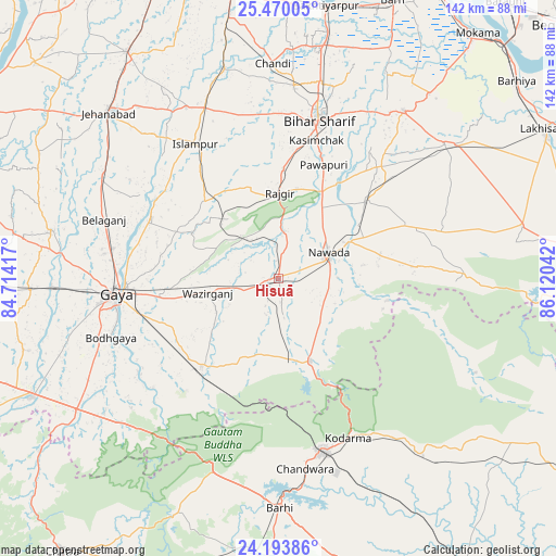
Hisuā GPS coordinates[2]
24° 50' 0.96" North, 85° 25' 2.244" East
| Map corner | latitude | longitude |
|---|---|---|
| Upper-left | 25.47005°, | 84.71417° |
| Center: | 24.8336°, | 85.41729° |
| Lower-right: | 24.19386°, | 86.12042° |
| Map W x H: | 141.9×141.9 km | = 88.2×88.2mi |
| max Lat: | 34.9274° ⇑37.4% North |
| Hisuā: | 24.8336° |
| min Lat: | ⇓62.6% South 8.09008° |
| min Long | Hisuā | max Long |
| 68.82655° | 85.41729° | 96.81° |
| W 85.4%⇐ | ⇒14.6% E |
Elevation
Elevation of Hisuā is 101 m = 331 ft, and this is 194.6 m = 638 ft below average elevation for this country.
| Max E: |
3681 m = 12077 ft | 68.2% |
| Avg. | 295.6 m = 970 ft | |
| Hisuā | 101 m = 331 ft | |
Min E: |
1 m = 3 ft | 31.8% |
See also: India elevation on elevation.city.
Geographical zone
Hisuā is located in North temperate zone (between Tropic of Cancer and the Arctic Circle). Distance of this Northern Tropic circle is 155.3 km =96.5 mi to South.| Distance of | km | miles | from Hisuā |
|---|---|---|---|
| North Pole | 7245.8 | 4502.3 | to North |
| Arctic Circle | 4639.9 | 2883.1 | to North |
| Tropic Cancer | 155.3 | 96.5 | to South |
| Equator | 2761.2 | 1715.7 | to South |


Nearby cities:
15 places around Hisuā: (largest is in red/bold)
• Bagaha
49.5 km =30.8 mi,  226°
226°
• Bar Bigha
53.3 km =33.1 mi,  36°
36°
• Bihār Sharīf
42.2 km =26.2 mi,  14°
14°
• Buddh Gaya
46 km =28.6 mi,  250°
250°
• Gaya
41.9 km =26 mi,  264°
264°
• Hilsa
55.4 km =34.4 mi,  345°
345°
• Islāmpur
40.3 km =25 mi,  328°
328°
• Jumri Tilaiyā
45.8 km =28.5 mi,  165°
165°
• Kodarmā
44.4 km =27.6 mi,  156°
156°
• Nawāda
14 km =8.7 mi,  65°
65°
• Rājgīr
21.6 km =13.4 mi,  0°
0°
• Sheikhpura
54.6 km =33.9 mi,  51°
51°
• Silao
27.8 km =17.3 mi, 2°
• Tekāri
59.2 km =36.8 mi,  281°
281°
• Wāris Alīganj
30.4 km =18.9 mi, 47°
Sources, notices
• [Note1] Compared only with cities in India existing in our database
• [Src1] Map data: © OpenStreetMap contributors (CC-BY-SA)
• [Src2] Other city data from geonames.org with taken over terms of usage.
• [Src3] Geographical zone / Annual Mean Temperature by Robert A. Rohde @ Wikipedia
