Bālugaon geodata
Bālugaon (Odisha) is a populated place; located in India in Asia/Kolkata (GMT+5.5) time zone. With population of 17,238 people, there are 2265 cities with bigger population in this country. Compared to other cities in India, 64.6% of cities are located further ↑North; 84.6% of cities are located further ←West and 72.7% of cities have higher elevation than Bālugaon. Note1


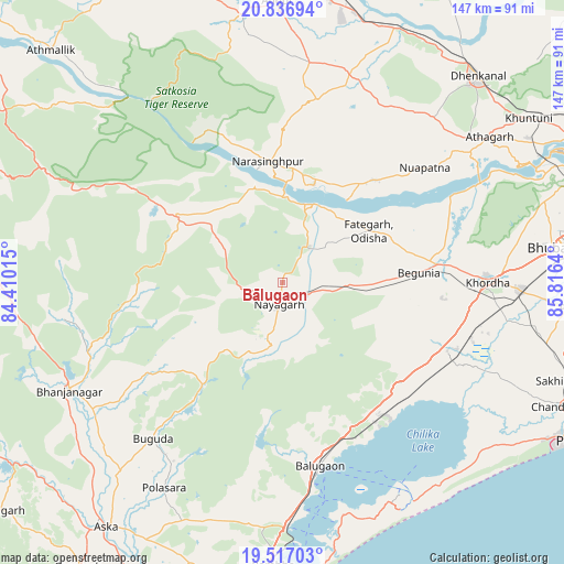
Bālugaon GPS coordinates[2]
20° 10' 42.168" North, 85° 6' 47.772" East
| Map corner | latitude | longitude |
|---|---|---|
| Upper-left | 20.83694°, | 84.41015° |
| Center: | 20.17838°, | 85.11327° |
| Lower-right: | 19.51703°, | 85.8164° |
| Map W x H: | 146.8×146.8 km | = 91.2×91.2mi |
| max Lat: | 34.9274° ⇑64.6% North |
| Bālugaon: | 20.17838° |
| min Lat: | ⇓35.4% South 8.09008° |
| min Long | Bālugaon | max Long |
| 68.82655° | 85.11327° | 96.81° |
| W 84.6%⇐ | ⇒15.4% E |
Elevation
Elevation of Bālugaon is 81 m = 266 ft, and this is 214.6 m = 704 ft below average elevation for this country.
| Max E: |
3681 m = 12077 ft | 72.7% |
| Avg. | 295.6 m = 970 ft | |
| Bālugaon | 81 m = 266 ft | |
Min E: |
1 m = 3 ft | 27.3% |
See also: India elevation on elevation.city.
Geographical zone
Bālugaon is located in North Torrid zone (between Equator and Tropic of Cancer). Distance of this Northern Tropic circle is 362.3 km =225.1 mi to North.| Distance of | km | miles | from Bālugaon |
|---|---|---|---|
| North Pole | 7763.4 | 4824 | to North |
| Arctic Circle | 5157.5 | 3204.7 | to North |
| Tropic Cancer | 362.3 | 225.1 | to North |
| Equator | 2243.6 | 1394.1 | to South |


Nearby cities:
15 places around Bālugaon: (largest is in red/bold)
• Belaguntha
59.6 km =37 mi,  236°
236°
• Bhanjanagar
62.1 km =38.6 mi, 243°
• Buguda
53.2 km =33.1 mi,  219°
219°
• Bānapur
44.8 km =27.8 mi,  172°
172°
• Bānki
48.8 km =30.3 mi,  62°
62°
• Dhenkānāl
73.3 km =45.5 mi,  43°
43°
• Jatani
62 km =38.5 mi,  91°
91°
• Kantilo
22 km =13.7 mi,  21°
21°
• Khallikot
63.4 km =39.4 mi,  182°
182°
• Khurda
52.5 km =32.6 mi, 89°
• Kodala
64.2 km =39.9 mi,  196°
196°
• Nayāgarh
5.8 km =3.6 mi, 197°
• Polasara
62.3 km =38.7 mi,  210°
210°
• Rambha
73.6 km =45.7 mi, 181°
• Āthagarh
65.9 km =40.9 mi,  54°
54°
Sources, notices
• [Note1] Compared only with cities in India existing in our database
• [Src1] Map data: © OpenStreetMap contributors (CC-BY-SA)
• [Src2] Other city data from geonames.org with taken over terms of usage.
• [Src3] Geographical zone / Annual Mean Temperature by Robert A. Rohde @ Wikipedia
