Bakreswar geodata
Bakreswar (West Bengal) is a populated place; located in India in Asia/Kolkata (GMT+5.5) time zone. With population of 1,739 people, there are 3443 cities with bigger population in this country. Compared to other cities in India, 57.5% of cities are located further ↓South; 90% of cities are located further ←West and 69.9% of cities have higher elevation than Bakreswar. Note1


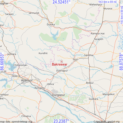
Bakreswar GPS coordinates[2]
23° 52' 59.52" North, 87° 22' 21.54" East
| Map corner | latitude | longitude |
|---|---|---|
| Upper-left | 24.52451°, | 86.66953° |
| Center: | 23.8832°, | 87.37265° |
| Lower-right: | 23.2387°, | 88.07578° |
| Map W x H: | 143×143 km | = 88.9×88.9mi |
| max Lat: | 34.9274° ⇑42.5% North |
| Bakreswar: | 23.8832° |
| min Lat: | ⇓57.5% South 8.09008° |
| min Long | Bakreswar | max Long |
| 68.82655° | 87.37265° | 96.81° |
| W 90%⇐ | ⇒10% E |
Elevation
Elevation of Bakreswar is 92 m = 302 ft, and this is 203.6 m = 668 ft below average elevation for this country.
| Max E: |
3681 m = 12077 ft | 69.9% |
| Avg. | 295.6 m = 970 ft | |
| Bakreswar | 92 m = 302 ft | |
Min E: |
1 m = 3 ft | 30.1% |
See also: India elevation on elevation.city.
Geographical zone
Bakreswar is located in North temperate zone (between Tropic of Cancer and the Arctic Circle). Distance of this Northern Tropic circle is 49.6 km =30.8 mi to South.| Distance of | km | miles | from Bakreswar |
|---|---|---|---|
| North Pole | 7351.5 | 4568 | to North |
| Arctic Circle | 4745.6 | 2948.8 | to North |
| Tropic Cancer | 49.6 | 30.8 | to South |
| Equator | 2655.6 | 1650.1 | to South |


Nearby cities:
15 places around Bakreswar: (largest is in red/bold)
• Ahmadpur
32.5 km =20.2 mi,  100°
100°
• Bahula
33.3 km =20.7 mi,  219°
219°
• Barjora
51.4 km =31.9 mi,  189°
189°
• Bolpur
41.1 km =25.5 mi,  126°
126°
• Chittaranjan
47.8 km =29.7 mi,  266°
266°
• Dubrājpur
10.3 km =6.4 mi,  177°
177°
• Dumka
44.6 km =27.7 mi,  343°
343°
• Durgapur
41.4 km =25.7 mi, 189°
• Jāmuria
35.9 km =22.3 mi,  236°
236°
• Kulti
56.4 km =35 mi,  252°
252°
• Rampur Hat
53 km =32.9 mi,  51°
51°
• Rānīganj
38.6 km =24 mi, 219°
• Sainthia
32.1 km =19.9 mi,  76°
76°
• Siuri
16 km =9.9 mi, 80°
• Āsansol
45.4 km =28.2 mi, 240°
Sources, notices
• [Note1] Compared only with cities in India existing in our database
• [Src1] Map data: © OpenStreetMap contributors (CC-BY-SA)
• [Src2] Other city data from geonames.org with taken over terms of usage.
• [Src3] Geographical zone / Annual Mean Temperature by Robert A. Rohde @ Wikipedia
