Dayāl Bāgh geodata
Dayāl Bāgh (Uttar Pradesh) is a populated place; located in India in Asia/Kolkata (GMT+5.5) time zone. With population of 3,367 people, there are 3399 cities with bigger population in this country. Compared to other cities in India, 80.2% of cities are located further ↓South; 51.2% of cities are located further →East and 56.4% of cities have higher elevation than Dayāl Bāgh. Note1


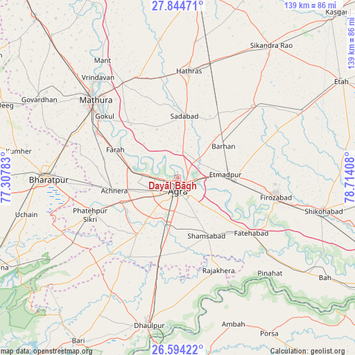
Dayāl Bāgh GPS coordinates[2]
27° 13' 16.392" North, 78° 0' 39.42" East
| Map corner | latitude | longitude |
|---|---|---|
| Upper-left | 27.84471°, | 77.30783° |
| Center: | 27.22122°, | 78.01095° |
| Lower-right: | 26.59422°, | 78.71408° |
| Map W x H: | 139×139 km | = 86.4×86.4mi |
| max Lat: | 34.9274° ⇑19.8% North |
| Dayāl Bāgh: | 27.22122° |
| min Lat: | ⇓80.2% South 8.09008° |
| min Long | Dayāl Bāgh | max Long |
| 68.82655° | 78.01095° | 96.81° |
| W 48.8%⇐ | ⇒51.2% E |
Elevation
Elevation of Dayāl Bāgh is 168 m = 551 ft, and this is 127.6 m = 419 ft below average elevation for this country.
| Max E: |
3681 m = 12077 ft | 56.4% |
| Avg. | 295.6 m = 970 ft | |
| Dayāl Bāgh | 168 m = 551 ft | |
Min E: |
1 m = 3 ft | 43.6% |
See also: India elevation on elevation.city.
Geographical zone
Dayāl Bāgh is located in North temperate zone (between Tropic of Cancer and the Arctic Circle). Distance of this Northern Tropic circle is 420.8 km =261.5 mi to South.| Distance of | km | miles | from Dayāl Bāgh |
|---|---|---|---|
| North Pole | 6980.3 | 4337.4 | to North |
| Arctic Circle | 4374.5 | 2718.2 | to North |
| Tropic Cancer | 420.8 | 261.5 | to South |
| Equator | 3026.7 | 1880.7 | to South |


Nearby cities:
15 places around Dayāl Bāgh: (largest is in red/bold)
• Achhnera
25.6 km =15.9 mi,  259°
259°
• Agra
4.3 km =2.7 mi,  172°
172°
• Baldev
27.8 km =17.3 mi,  317°
317°
• Farah
27 km =16.8 mi,  294°
294°
• Fatehpur Sīkri
37.5 km =23.3 mi,  247°
247°
• Fatehābād
36.1 km =22.4 mi,  126°
126°
• Fīrozābād
39.1 km =24.3 mi,  101°
101°
• Gokul
37.6 km =23.4 mi,  310°
310°
• Itimādpur
18.6 km =11.6 mi,  85°
85°
• Khairāgarh
36.3 km =22.6 mi,  211°
211°
• Kiraoli
24.2 km =15 mi, 247°
• Mahāban
35.4 km =22 mi, 311°
• Sadābād
24.3 km =15.1 mi,  6°
6°
• Shamsābād
25.3 km =15.7 mi,  153°
153°
• Tūndla
22.3 km =13.9 mi, 91°
Sources, notices
• [Note1] Compared only with cities in India existing in our database
• [Src1] Map data: © OpenStreetMap contributors (CC-BY-SA)
• [Src2] Other city data from geonames.org with taken over terms of usage.
• [Src3] Geographical zone / Annual Mean Temperature by Robert A. Rohde @ Wikipedia
