Ahmadpur geodata
Ahmadpur (West Bengal) is a populated place; located in India in Asia/Kolkata (GMT+5.5) time zone. With population of 8,855 people, there are 3054 cities with bigger population in this country. Compared to other cities in India, 57% of cities are located further ↓South; 90.5% of cities are located further ←West and 79.2% of cities have higher elevation than Ahmadpur. Note1


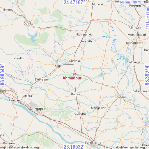
Ahmadpur GPS coordinates[2]
23° 49' 48.324" North, 87° 41' 11.796" East
| Map corner | latitude | longitude |
|---|---|---|
| Upper-left | 24.47167°, | 86.98349° |
| Center: | 23.83009°, | 87.68661° |
| Lower-right: | 23.18532°, | 88.38974° |
| Map W x H: | 143×143 km | = 88.9×88.9mi |
| max Lat: | 34.9274° ⇑43% North |
| Ahmadpur: | 23.83009° |
| min Lat: | ⇓57% South 8.09008° |
| min Long | Ahmadpur | max Long |
| 68.82655° | 87.68661° | 96.81° |
| W 90.5%⇐ | ⇒9.5% E |
Elevation
Elevation of Ahmadpur is 51 m = 167 ft, and this is 244.6 m = 802 ft below average elevation for this country.
| Max E: |
3681 m = 12077 ft | 79.2% |
| Avg. | 295.6 m = 970 ft | |
| Ahmadpur | 51 m = 167 ft | |
Min E: |
1 m = 3 ft | 20.8% |
See also: India elevation on elevation.city.
Geographical zone
Ahmadpur is located in North temperate zone (between Tropic of Cancer and the Arctic Circle). Distance of this Northern Tropic circle is 43.7 km =27.2 mi to South.| Distance of | km | miles | from Ahmadpur |
|---|---|---|---|
| North Pole | 7357.4 | 4571.7 | to North |
| Arctic Circle | 4751.5 | 2952.4 | to North |
| Tropic Cancer | 43.7 | 27.2 | to South |
| Equator | 2649.7 | 1646.4 | to South |


Nearby cities:
15 places around Ahmadpur: (largest is in red/bold)
• Bahula
56.7 km =35.2 mi,  249°
249°
• Bakreswar
32.5 km =20.2 mi,  280°
280°
• Barjora
60.3 km =37.5 mi,  222°
222°
• Beldānga
59.5 km =37 mi,  78°
78°
• Bolpur
18.6 km =11.6 mi,  176°
176°
• Dubrājpur
31.9 km =19.8 mi,  261°
261°
• Durgapur
52 km =32.3 mi,  227°
227°
• Guskhara
37.8 km =23.5 mi,  172°
172°
• Kāndi
38.7 km =24 mi,  68°
68°
• Kātoya
49.8 km =30.9 mi,  114°
114°
• Nalhāti
53.9 km =33.5 mi,  15°
15°
• Rampur Hat
39.8 km =24.7 mi,  14°
14°
• Rānīganj
61.4 km =38.2 mi, 247°
• Sainthia
13.2 km =8.2 mi,  357°
357°
• Siuri
18.3 km =11.4 mi,  298°
298°
Sources, notices
• [Note1] Compared only with cities in India existing in our database
• [Src1] Map data: © OpenStreetMap contributors (CC-BY-SA)
• [Src2] Other city data from geonames.org with taken over terms of usage.
• [Src3] Geographical zone / Annual Mean Temperature by Robert A. Rohde @ Wikipedia
