Sainthia geodata
Sainthia (West Bengal) is a populated place; located in India in Asia/Kolkata (GMT+5.5) time zone. With population of 43,221 people, there are 1022 cities with bigger population in this country. Compared to other cities in India, 57.9% of cities are located further ↓South; 90.5% of cities are located further ←West and 76.7% of cities have higher elevation than Sainthia. Note1


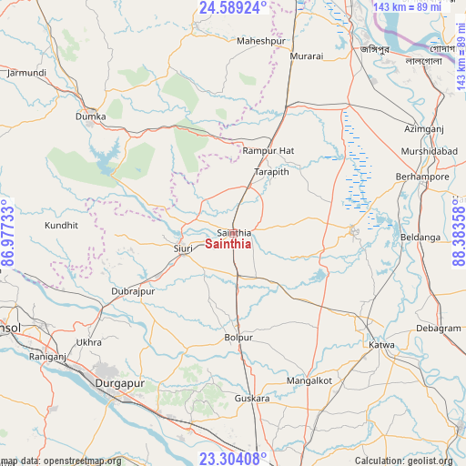
Sainthia GPS coordinates[2]
23° 56' 53.736" North, 87° 40' 49.62" East
| Map corner | latitude | longitude |
|---|---|---|
| Upper-left | 24.58924°, | 86.97733° |
| Center: | 23.94826°, | 87.68045° |
| Lower-right: | 23.30408°, | 88.38358° |
| Map W x H: | 142.9×142.9 km | = 88.8×88.8mi |
| max Lat: | 34.9274° ⇑42.1% North |
| Sainthia: | 23.94826° |
| min Lat: | ⇓57.9% South 8.09008° |
| min Long | Sainthia | max Long |
| 68.82655° | 87.68045° | 96.81° |
| W 90.5%⇐ | ⇒9.5% E |
Elevation
Elevation of Sainthia is 60 m = 197 ft, and this is 235.6 m = 773 ft below average elevation for this country.
| Max E: |
3681 m = 12077 ft | 76.7% |
| Avg. | 295.6 m = 970 ft | |
| Sainthia | 60 m = 197 ft | |
Min E: |
1 m = 3 ft | 23.3% |
See also: Sainthia elevation on elevation.city.
Geographical zone
Sainthia is located in North temperate zone (between Tropic of Cancer and the Arctic Circle). Distance of this Northern Tropic circle is 56.9 km =35.4 mi to South.| Distance of | km | miles | from Sainthia |
|---|---|---|---|
| North Pole | 7344.3 | 4563.5 | to North |
| Arctic Circle | 4738.4 | 2944.3 | to North |
| Tropic Cancer | 56.9 | 35.4 | to South |
| Equator | 2662.8 | 1654.6 | to South |


Nearby cities:
15 places around Sainthia: (largest is in red/bold)
• Ahmadpur
13.2 km =8.2 mi,  177°
177°
• Baharampur
60.6 km =37.7 mi,  73°
73°
• Bahula
62 km =38.5 mi,  237°
237°
• Bakreswar
32.1 km =19.9 mi,  256°
256°
• Beldānga
58.9 km =36.6 mi,  91°
91°
• Bolpur
31.8 km =19.8 mi, 176°
• Dubrājpur
35.6 km =22.1 mi, 240°
• Dumka
56.4 km =35 mi,  309°
309°
• Durgapur
61.2 km =38 mi,  218°
218°
• Guskhara
50.9 km =31.6 mi,  173°
173°
• Kāndi
36.6 km =22.7 mi, 88°
• Kātoya
57 km =35.4 mi,  126°
126°
• Nalhāti
41.6 km =25.8 mi,  21°
21°
• Rampur Hat
27.5 km =17.1 mi, 22°
• Siuri
16.2 km =10.1 mi,  253°
253°
Sources, notices
• [Note1] Compared only with cities in India existing in our database
• [Src1] Map data: © OpenStreetMap contributors (CC-BY-SA)
• [Src2] Other city data from geonames.org with taken over terms of usage.
• [Src3] Geographical zone / Annual Mean Temperature by Robert A. Rohde @ Wikipedia
