Warud geodata
Warud (Maharashtra) is a populated place; located in India in Asia/Kolkata (GMT+5.5) time zone. With population of 47,817 people, there are 920 cities with bigger population in this country. Compared to other cities in India, 59.1% of cities are located further ↑North; 52% of cities are located further ←West and 76.2% of cities have lower elevation than Warud. Note1


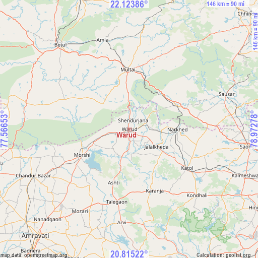
Warud GPS coordinates[2]
21° 28' 15.636" North, 78° 16' 10.74" East
| Map corner | latitude | longitude |
|---|---|---|
| Upper-left | 22.12386°, | 77.56653° |
| Center: | 21.47101°, | 78.26965° |
| Lower-right: | 20.81522°, | 78.97278° |
| Map W x H: | 145.5×145.5 km | = 90.4×90.4mi |
| max Lat: | 34.9274° ⇑59.1% North |
| Warud: | 21.47101° |
| min Lat: | ⇓40.9% South 8.09008° |
| min Long | Warud | max Long |
| 68.82655° | 78.26965° | 96.81° |
| W 52%⇐ | ⇒48% E |
Elevation
Elevation of Warud is 402 m = 1319 ft, and this is 106.4 m = 349 ft above average elevation for this country.
| Max E: |
3681 m = 12077 ft | 23.8% |
| Warud | 402 m 1319 ft | |
| Avg. | 295.6 m = 970 ft | |
Min E: |
1 m = 3 ft | 76.2% |
See also: Warud elevation on elevation.city.
Geographical zone
Warud is located in North Torrid zone (between Equator and Tropic of Cancer). Distance of this Northern Tropic circle is 218.6 km =135.8 mi to North.| Distance of | km | miles | from Warud |
|---|---|---|---|
| North Pole | 7619.7 | 4734.7 | to North |
| Arctic Circle | 5013.8 | 3115.4 | to North |
| Tropic Cancer | 218.6 | 135.8 | to North |
| Equator | 2387.4 | 1483.5 | to South |


Nearby cities:
15 places around Warud: (largest is in red/bold)
• Amla
52.5 km =32.6 mi,  343°
343°
• Betūl
61 km =37.9 mi,  321°
321°
• Betūl Bazār
55.4 km =34.4 mi, 320°
• Chāndūr Bāzār
60 km =37.3 mi,  244°
244°
• Kātol
39.4 km =24.5 mi,  123°
123°
• Lodhīkheda
62.2 km =38.6 mi,  78°
78°
• Mohgaon
51.8 km =32.2 mi,  68°
68°
• Mohpa
60.7 km =37.7 mi,  107°
107°
• Morsi
30.3 km =18.8 mi, 241°
• Mowād
18.8 km =11.7 mi,  92°
92°
• Multai
33.8 km =21 mi,  357°
357°
• Pāndhurnā
29.9 km =18.6 mi,  62°
62°
• Saoner
68.1 km =42.3 mi,  98°
98°
• Sausar
58.2 km =36.2 mi, 69°
• Ārvi
53 km =32.9 mi,  184°
184°
Sources, notices
• [Note1] Compared only with cities in India existing in our database
• [Src1] Map data: © OpenStreetMap contributors (CC-BY-SA)
• [Src2] Other city data from geonames.org with taken over terms of usage.
• [Src3] Geographical zone / Annual Mean Temperature by Robert A. Rohde @ Wikipedia
