Mahgawān geodata
Mahgawān (Madhya Pradesh) is a populated place; located in India in Asia/Kolkata (GMT+5.5) time zone. With population of 16,176 people, there are 2357 cities with bigger population in this country. Compared to other cities in India, 74.6% of cities are located further ↓South; 55.3% of cities are located further ←West and 58.7% of cities have higher elevation than Mahgawān. Note1


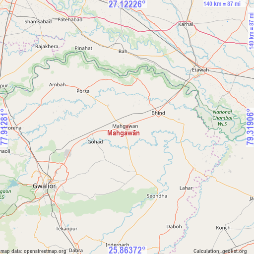
Mahgawān GPS coordinates[2]
26° 29' 40.956" North, 78° 36' 57.348" East
| Map corner | latitude | longitude |
|---|---|---|
| Upper-left | 27.12226°, | 77.91281° |
| Center: | 26.49471°, | 78.61593° |
| Lower-right: | 25.86372°, | 79.31906° |
| Map W x H: | 139.9×139.9 km | = 86.9×86.9mi |
| max Lat: | 34.9274° ⇑25.4% North |
| Mahgawān: | 26.49471° |
| min Lat: | ⇓74.6% South 8.09008° |
| min Long | Mahgawān | max Long |
| 68.82655° | 78.61593° | 96.81° |
| W 55.3%⇐ | ⇒44.7% E |
Elevation
Elevation of Mahgawān is 154 m = 505 ft, and this is 141.6 m = 465 ft below average elevation for this country.
| Max E: |
3681 m = 12077 ft | 58.7% |
| Avg. | 295.6 m = 970 ft | |
| Mahgawān | 154 m = 505 ft | |
Min E: |
1 m = 3 ft | 41.3% |
See also: India elevation on elevation.city.
Geographical zone
Mahgawān is located in North temperate zone (between Tropic of Cancer and the Arctic Circle). Distance of this Northern Tropic circle is 340 km =211.3 mi to South.| Distance of | km | miles | from Mahgawān |
|---|---|---|---|
| North Pole | 7061.1 | 4387.6 | to North |
| Arctic Circle | 4455.2 | 2768.3 | to North |
| Tropic Cancer | 340 | 211.3 | to South |
| Equator | 2945.9 | 1830.5 | to South |


Nearby cities:
15 places around Mahgawān: (largest is in red/bold)
• Ambāh
45.2 km =28.1 mi,  301°
301°
• Bhind
18.8 km =11.7 mi,  64°
64°
• Bāh
41.7 km =25.9 mi,  356°
356°
• Etāwah
51 km =31.7 mi,  52°
52°
• Gohadi
18.6 km =11.6 mi,  248°
248°
• Gwalior
53 km =32.9 mi,  236°
236°
• Jaswantnagar
51.7 km =32.1 mi,  33°
33°
• Lahār
46.6 km =29 mi,  135°
135°
• Mau
26 km =16.2 mi,  167°
167°
• Mihona
43.2 km =26.8 mi,  122°
122°
• Morār
49.1 km =30.5 mi,  232°
232°
• Pināhat
49.5 km =30.8 mi,  331°
331°
• Porsa
31.5 km =19.6 mi,  309°
309°
• Seondha
41.3 km =25.7 mi,  156°
156°
• Umri
32 km =19.9 mi,  86°
86°
Sources, notices
• [Note1] Compared only with cities in India existing in our database
• [Src1] Map data: © OpenStreetMap contributors (CC-BY-SA)
• [Src2] Other city data from geonames.org with taken over terms of usage.
• [Src3] Geographical zone / Annual Mean Temperature by Robert A. Rohde @ Wikipedia
