Bāh geodata
Bāh (Uttar Pradesh) is a populated place; located in India in Asia/Kolkata (GMT+5.5) time zone. With population of 15,359 people, there are 2429 cities with bigger population in this country. Compared to other cities in India, 77.4% of cities are located further ↓South; 55.1% of cities are located further ←West and 57.6% of cities have higher elevation than Bāh. Note1


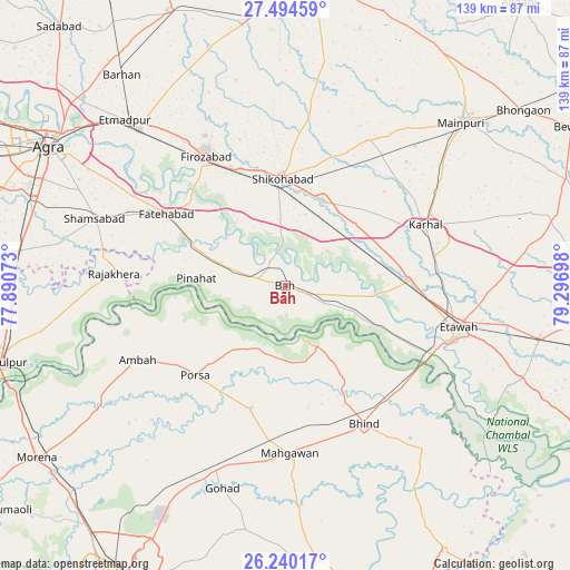
Bāh GPS coordinates[2]
26° 52' 8.832" North, 78° 35' 37.86" East
| Map corner | latitude | longitude |
|---|---|---|
| Upper-left | 27.49459°, | 77.89073° |
| Center: | 26.86912°, | 78.59385° |
| Lower-right: | 26.24017°, | 79.29698° |
| Map W x H: | 139.5×139.5 km | = 86.7×86.7mi |
| max Lat: | 34.9274° ⇑22.6% North |
| Bāh: | 26.86912° |
| min Lat: | ⇓77.4% South 8.09008° |
| min Long | Bāh | max Long |
| 68.82655° | 78.59385° | 96.81° |
| W 55.1%⇐ | ⇒44.9% E |
Elevation
Elevation of Bāh is 160 m = 525 ft, and this is 135.6 m = 445 ft below average elevation for this country.
| Max E: |
3681 m = 12077 ft | 57.6% |
| Avg. | 295.6 m = 970 ft | |
| Bāh | 160 m = 525 ft | |
Min E: |
1 m = 3 ft | 42.4% |
See also: India elevation on elevation.city.
Geographical zone
Bāh is located in North temperate zone (between Tropic of Cancer and the Arctic Circle). Distance of this Northern Tropic circle is 381.6 km =237.1 mi to South.| Distance of | km | miles | from Bāh |
|---|---|---|---|
| North Pole | 7019.5 | 4361.7 | to North |
| Arctic Circle | 4413.6 | 2742.5 | to North |
| Tropic Cancer | 381.6 | 237.1 | to South |
| Equator | 2987.6 | 1856.4 | to South |


Nearby cities:
15 places around Bāh: (largest is in red/bold)
• Ambāh
40.8 km =25.4 mi,  243°
243°
• Bhind
38.7 km =24 mi,  150°
150°
• Etāwah
43.7 km =27.2 mi,  103°
103°
• Fatehābād
33.7 km =20.9 mi,  301°
301°
• Fīrozābād
36.9 km =22.9 mi,  328°
328°
• Ghiror
40.7 km =25.3 mi,  29°
29°
• Jasrāna
41.2 km =25.6 mi,  8°
8°
• Jaswantnagar
30.7 km =19.1 mi,  87°
87°
• Karhal
37.3 km =23.2 mi,  66°
66°
• Mahgawān
41.7 km =25.9 mi,  176°
176°
• Pināhat
21.6 km =13.4 mi,  274°
274°
• Porsa
31 km =19.3 mi,  225°
225°
• Rājākhera
42.1 km =26.2 mi, 274°
• Shikohābād
26.6 km =16.5 mi,  358°
358°
• Sirsāganj
22.8 km =14.2 mi,  23°
23°
Sources, notices
• [Note1] Compared only with cities in India existing in our database
• [Src1] Map data: © OpenStreetMap contributors (CC-BY-SA)
• [Src2] Other city data from geonames.org with taken over terms of usage.
• [Src3] Geographical zone / Annual Mean Temperature by Robert A. Rohde @ Wikipedia
