Tūndla geodata
Tūndla (Uttar Pradesh) is a populated place; located in India in Asia/Kolkata (GMT+5.5) time zone. With population of 50,939 people, there are 873 cities with bigger population in this country. Compared to other cities in India, 80.1% of cities are located further ↓South; 51.6% of cities are located further ←West and 56.6% of cities have higher elevation than Tūndla. Note1


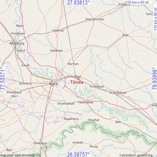
Tūndla GPS coordinates[2]
27° 12' 52.56" North, 78° 14' 12.588" East
| Map corner | latitude | longitude |
|---|---|---|
| Upper-left | 27.83813°, | 77.53371° |
| Center: | 27.2146°, | 78.23683° |
| Lower-right: | 26.58757°, | 78.93996° |
| Map W x H: | 139×139.1 km | = 86.4×86.4mi |
| max Lat: | 34.9274° ⇑19.9% North |
| Tūndla: | 27.2146° |
| min Lat: | ⇓80.1% South 8.09008° |
| min Long | Tūndla | max Long |
| 68.82655° | 78.23683° | 96.81° |
| W 51.6%⇐ | ⇒48.4% E |
Elevation
Elevation of Tūndla is 167 m = 548 ft, and this is 128.6 m = 422 ft below average elevation for this country.
| Max E: |
3681 m = 12077 ft | 56.6% |
| Avg. | 295.6 m = 970 ft | |
| Tūndla | 167 m = 548 ft | |
Min E: |
1 m = 3 ft | 43.4% |
See also: Tūndla elevation on elevation.city.
Geographical zone
Tūndla is located in North temperate zone (between Tropic of Cancer and the Arctic Circle). Distance of this Northern Tropic circle is 420.1 km =261 mi to South.| Distance of | km | miles | from Tūndla |
|---|---|---|---|
| North Pole | 6981.1 | 4337.9 | to North |
| Arctic Circle | 4375.2 | 2718.6 | to North |
| Tropic Cancer | 420.1 | 261 | to South |
| Equator | 3026 | 1880.3 | to South |


Nearby cities:
15 places around Tūndla: (largest is in red/bold)
• Agra
22 km =13.7 mi,  260°
260°
• Dayāl Bāgh
22.3 km =13.9 mi,  271°
271°
• Fatehābād
21.9 km =13.6 mi,  162°
162°
• Fīrozābād
17.4 km =10.8 mi,  113°
113°
• Hāthras
46.1 km =28.6 mi,  336°
336°
• Itimādpur
4.5 km =2.8 mi,  301°
301°
• Jalesar
29.5 km =18.3 mi,  12°
12°
• Jasrāna
41.2 km =25.6 mi,  86°
86°
• Kiraoli
45.5 km =28.3 mi, 259°
• Pharihā
26.2 km =16.3 mi,  62°
62°
• Pināhat
39.2 km =24.4 mi, 159°
• Rājākhera
35.8 km =22.2 mi,  190°
190°
• Sadābād
31.7 km =19.7 mi,  321°
321°
• Shamsābād
24.6 km =15.3 mi,  207°
207°
• Shikohābād
36.6 km =22.7 mi, 108°
Sources, notices
• [Note1] Compared only with cities in India existing in our database
• [Src1] Map data: © OpenStreetMap contributors (CC-BY-SA)
• [Src2] Other city data from geonames.org with taken over terms of usage.
• [Src3] Geographical zone / Annual Mean Temperature by Robert A. Rohde @ Wikipedia
