Fatehābād geodata
Fatehābād (Uttar Pradesh) is a populated place; located in India in Asia/Kolkata (GMT+5.5) time zone. With population of 21,957 people, there are 1905 cities with bigger population in this country. Compared to other cities in India, 78.6% of cities are located further ↓South; 52.4% of cities are located further ←West and 56.2% of cities have higher elevation than Fatehābād. Note1


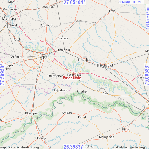
Fatehābād GPS coordinates[2]
27° 1' 35.22" North, 78° 18' 9.72" East
| Map corner | latitude | longitude |
|---|---|---|
| Upper-left | 27.65104°, | 77.59958° |
| Center: | 27.02645°, | 78.3027° |
| Lower-right: | 26.39837°, | 79.00583° |
| Map W x H: | 139.3×139.3 km | = 86.6×86.6mi |
| max Lat: | 34.9274° ⇑21.4% North |
| Fatehābād: | 27.02645° |
| min Lat: | ⇓78.6% South 8.09008° |
| min Long | Fatehābād | max Long |
| 68.82655° | 78.3027° | 96.81° |
| W 52.4%⇐ | ⇒47.6% E |
Elevation
Elevation of Fatehābād is 169 m = 554 ft, and this is 126.6 m = 415 ft below average elevation for this country.
| Max E: |
3681 m = 12077 ft | 56.2% |
| Avg. | 295.6 m = 970 ft | |
| Fatehābād | 169 m = 554 ft | |
Min E: |
1 m = 3 ft | 43.8% |
See also: India elevation on elevation.city.
Geographical zone
Fatehābād is located in North temperate zone (between Tropic of Cancer and the Arctic Circle). Distance of this Northern Tropic circle is 399.1 km =248 mi to South.| Distance of | km | miles | from Fatehābād |
|---|---|---|---|
| North Pole | 7002 | 4350.8 | to North |
| Arctic Circle | 4396.1 | 2731.6 | to North |
| Tropic Cancer | 399.1 | 248 | to South |
| Equator | 3005.1 | 1867.3 | to South |


Nearby cities:
15 places around Fatehābād: (largest is in red/bold)
• Agra
33.3 km =20.7 mi,  301°
301°
• Ambāh
36.6 km =22.7 mi,  191°
191°
• Bāh
33.7 km =20.9 mi,  121°
121°
• Dayāl Bāgh
36.1 km =22.4 mi,  306°
306°
• Fīrozābād
16.7 km =10.4 mi,  34°
34°
• Itimādpur
25.4 km =15.8 mi,  336°
336°
• Jasrāna
41.7 km =25.9 mi,  56°
56°
• Pharihā
36.9 km =22.9 mi, 27°
• Pināhat
17.4 km =10.8 mi,  155°
155°
• Porsa
39.7 km =24.7 mi,  170°
170°
• Rājākhera
19.3 km =12 mi,  222°
222°
• Shamsābād
17.8 km =11.1 mi,  266°
266°
• Shikohābād
29.5 km =18.3 mi,  72°
72°
• Sirsāganj
38.2 km =23.7 mi,  84°
84°
• Tūndla
21.9 km =13.6 mi, 342°
Sources, notices
• [Note1] Compared only with cities in India existing in our database
• [Src1] Map data: © OpenStreetMap contributors (CC-BY-SA)
• [Src2] Other city data from geonames.org with taken over terms of usage.
• [Src3] Geographical zone / Annual Mean Temperature by Robert A. Rohde @ Wikipedia
