Khāmgaon geodata
Khāmgaon (Maharashtra) is a populated place; located in India in Asia/Kolkata (GMT+5.5) time zone. With population of 94,604 people, there are 471 cities with bigger population in this country. Compared to other cities in India, 63.1% of cities are located further ↑North; 67.7% of cities are located further →East and 67.3% of cities have lower elevation than Khāmgaon. Note1


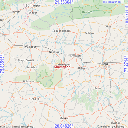
Khāmgaon GPS coordinates[2]
20° 42' 26.568" North, 76° 34' 5.772" East
| Map corner | latitude | longitude |
|---|---|---|
| Upper-left | 21.36364°, | 75.86515° |
| Center: | 20.70738°, | 76.56827° |
| Lower-right: | 20.04826°, | 77.2714° |
| Map W x H: | 146.3×146.3 km | = 90.9×90.9mi |
| max Lat: | 34.9274° ⇑63.1% North |
| Khāmgaon: | 20.70738° |
| min Lat: | ⇓36.9% South 8.09008° |
| min Long | Khāmgaon | max Long |
| 68.82655° | 76.56827° | 96.81° |
| W 32.3%⇐ | ⇒67.7% E |
Elevation
Elevation of Khāmgaon is 304 m = 997 ft, and this is 8.4 m = 28 ft above average elevation for this country.
| Max E: |
3681 m = 12077 ft | 32.7% |
| Khāmgaon | 304 m 997 ft | |
| Avg. | 295.6 m = 970 ft | |
Min E: |
1 m = 3 ft | 67.3% |
See also: Khāmgaon elevation on elevation.city.
Geographical zone
Khāmgaon is located in North Torrid zone (between Equator and Tropic of Cancer). Distance of this Northern Tropic circle is 303.5 km =188.6 mi to North.| Distance of | km | miles | from Khāmgaon |
|---|---|---|---|
| North Pole | 7704.6 | 4787.4 | to North |
| Arctic Circle | 5098.7 | 3168.2 | to North |
| Tropic Cancer | 303.5 | 188.6 | to North |
| Equator | 2302.4 | 1430.6 | to South |


Nearby cities:
15 places around Khāmgaon: (largest is in red/bold)
• Akola
44.7 km =27.8 mi,  89°
89°
• Akot
66.8 km =41.5 mi,  49°
49°
• Buldāna
44.6 km =27.7 mi,  243°
243°
• Burhānpur
75.5 km =46.9 mi,  332°
332°
• Bālāpur
21.9 km =13.6 mi,  102°
102°
• Chikhli
51.2 km =31.8 mi,  219°
219°
• Jalgaon Jamod
38.5 km =23.9 mi,  354°
354°
• Malkāpur
43.2 km =26.8 mi,  297°
297°
• Mehekar
61.9 km =38.5 mi,  179°
179°
• Nāndūra Buzurg
18.1 km =11.2 mi,  321°
321°
• Pātūr
47.2 km =29.3 mi,  125°
125°
• Shegaon
16.6 km =10.3 mi, 54°
• Shāhpur
68.8 km =42.8 mi, 328°
• Telhāra
45.3 km =28.1 mi,  38°
38°
• Varangaon
76.6 km =47.6 mi, 296°
Sources, notices
• [Note1] Compared only with cities in India existing in our database
• [Src1] Map data: © OpenStreetMap contributors (CC-BY-SA)
• [Src2] Other city data from geonames.org with taken over terms of usage.
• [Src3] Geographical zone / Annual Mean Temperature by Robert A. Rohde @ Wikipedia
