Jalgaon Jamod geodata
Jalgaon Jamod (Maharashtra) is a populated place; located in India in Asia/Kolkata (GMT+5.5) time zone. With population of 27,794 people, there are 1551 cities with bigger population in this country. Compared to other cities in India, 61.4% of cities are located further ↑North; 68% of cities are located further →East and 68.2% of cities have lower elevation than Jalgaon Jamod. Note1


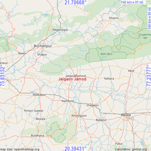
Jalgaon Jamod GPS coordinates[2]
21° 3' 6.984" North, 76° 32' 4.704" East
| Map corner | latitude | longitude |
|---|---|---|
| Upper-left | 21.70668°, | 75.83152° |
| Center: | 21.05194°, | 76.53464° |
| Lower-right: | 20.39431°, | 77.23777° |
| Map W x H: | 145.9×145.9 km | = 90.7×90.7mi |
| max Lat: | 34.9274° ⇑61.4% North |
| Jalgaon Jamod: | 21.05194° |
| min Lat: | ⇓38.6% South 8.09008° |
| min Long | Jalgaon Jamod | max Long |
| 68.82655° | 76.53464° | 96.81° |
| W 32%⇐ | ⇒68% E |
Elevation
Elevation of Jalgaon Jamod is 309 m = 1014 ft, and this is 13.4 m = 44 ft above average elevation for this country.
| Max E: |
3681 m = 12077 ft | 31.8% |
| Jalgaon Jamod | 309 m 1014 ft | |
| Avg. | 295.6 m = 970 ft | |
Min E: |
1 m = 3 ft | 68.2% |
See also: India elevation on elevation.city.
Geographical zone
Jalgaon Jamod is located in North Torrid zone (between Equator and Tropic of Cancer). Distance of this Northern Tropic circle is 265.2 km =164.8 mi to North.| Distance of | km | miles | from Jalgaon Jamod |
|---|---|---|---|
| North Pole | 7666.3 | 4763.6 | to North |
| Arctic Circle | 5060.4 | 3144.4 | to North |
| Tropic Cancer | 265.2 | 164.8 | to North |
| Equator | 2340.8 | 1454.5 | to South |


Nearby cities:
15 places around Jalgaon Jamod: (largest is in red/bold)
• Akola
61.4 km =38.2 mi,  128°
128°
• Akot
54.6 km =33.9 mi,  84°
84°
• Buldāna
68.6 km =42.6 mi,  212°
212°
• Burhānpur
42.6 km =26.5 mi,  312°
312°
• Bālāpur
49.6 km =30.8 mi,  149°
149°
• Khāmgaon
38.5 km =23.9 mi,  174°
174°
• Malkāpur
39.4 km =24.5 mi,  242°
242°
• Nepānagar
47 km =29.2 mi,  341°
341°
• Nāndūra Buzurg
25.4 km =15.8 mi,  197°
197°
• Rāver
56.2 km =34.9 mi,  292°
292°
• Shegaon
33.5 km =20.8 mi, 149°
• Shāhpur
38.1 km =23.7 mi,  302°
302°
• Sāvda
67.8 km =42.1 mi,  279°
279°
• Telhāra
31.7 km =19.7 mi,  95°
95°
• Varangaon
64.9 km =40.3 mi,  266°
266°
Sources, notices
• [Note1] Compared only with cities in India existing in our database
• [Src1] Map data: © OpenStreetMap contributors (CC-BY-SA)
• [Src2] Other city data from geonames.org with taken over terms of usage.
• [Src3] Geographical zone / Annual Mean Temperature by Robert A. Rohde @ Wikipedia
