Nāndūra Buzurg geodata
Nāndūra Buzurg (Maharashtra) is a populated place; located in India in Asia/Kolkata (GMT+5.5) time zone. With population of 39,650 people, there are 1117 cities with bigger population in this country. Compared to other cities in India, 62.3% of cities are located further ↑North; 68.9% of cities are located further →East and 63% of cities have lower elevation than Nāndūra Buzurg. Note1


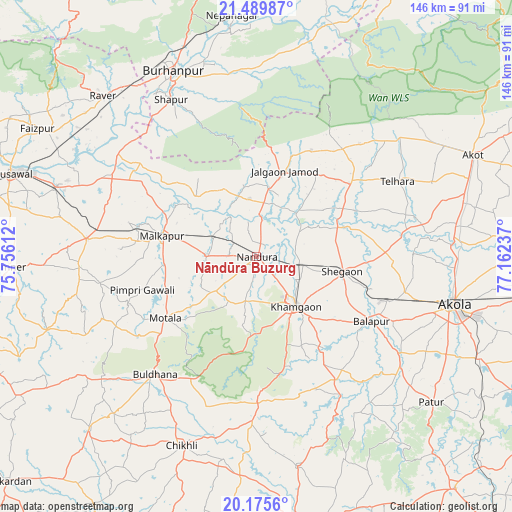
Nāndūra Buzurg GPS coordinates[2]
20° 50' 3.012" North, 76° 27' 33.264" East
| Map corner | latitude | longitude |
|---|---|---|
| Upper-left | 21.48987°, | 75.75612° |
| Center: | 20.83417°, | 76.45924° |
| Lower-right: | 20.1756°, | 77.16237° |
| Map W x H: | 146.1×146.1 km | = 90.8×90.8mi |
| max Lat: | 34.9274° ⇑62.3% North |
| Nāndūra Buzurg: | 20.83417° |
| min Lat: | ⇓37.7% South 8.09008° |
| min Long | Nāndūra Buzur | max Long |
| 68.82655° | 76.45924° | 96.81° |
| W 31.1%⇐ | ⇒68.9% E |
Elevation
Elevation of Nāndūra Buzurg is 271 m = 889 ft, and this is 24.6 m = 81 ft below average elevation for this country.
| Max E: |
3681 m = 12077 ft | 37% |
| Avg. | 295.6 m = 970 ft | |
| Nāndūra Buzurg | 271 m = 889 ft | |
Min E: |
1 m = 3 ft | 63% |
See also: India elevation on elevation.city.
Geographical zone
Nāndūra Buzurg is located in North Torrid zone (between Equator and Tropic of Cancer). Distance of this Northern Tropic circle is 289.4 km =179.8 mi to North.| Distance of | km | miles | from Nāndūra Buzurg |
|---|---|---|---|
| North Pole | 7690.5 | 4778.7 | to North |
| Arctic Circle | 5084.6 | 3159.4 | to North |
| Tropic Cancer | 289.4 | 179.8 | to North |
| Equator | 2316.5 | 1439.4 | to South |


Nearby cities:
15 places around Nāndūra Buzurg: (largest is in red/bold)
• Akola
57.7 km =35.9 mi,  103°
103°
• Akot
68.7 km =42.7 mi,  64°
64°
• Buldāna
44.3 km =27.5 mi,  220°
220°
• Burhānpur
57.9 km =36 mi,  335°
335°
• Bālāpur
37.7 km =23.4 mi,  119°
119°
• Chikhli
57.7 km =35.9 mi,  201°
201°
• Jalgaon Jamod
25.4 km =15.8 mi,  17°
17°
• Khāmgaon
18.1 km =11.2 mi,  141°
141°
• Malkāpur
27.6 km =17.1 mi,  281°
281°
• Pātūr
64.8 km =40.3 mi,  129°
129°
• Rāver
63.6 km =39.5 mi,  316°
316°
• Shegaon
25.4 km =15.8 mi, 100°
• Shāhpur
51 km =31.7 mi,  331°
331°
• Telhāra
44.9 km =27.9 mi, 61°
• Varangaon
60.5 km =37.6 mi,  289°
289°
Sources, notices
• [Note1] Compared only with cities in India existing in our database
• [Src1] Map data: © OpenStreetMap contributors (CC-BY-SA)
• [Src2] Other city data from geonames.org with taken over terms of usage.
• [Src3] Geographical zone / Annual Mean Temperature by Robert A. Rohde @ Wikipedia
