Thakurdwara geodata
Thakurdwara (Uttar Pradesh) is a populated place; located in India in Asia/Kolkata (GMT+5.5) time zone. With population of 39,860 people, there are 1112 cities with bigger population in this country. Compared to other cities in India, 89.7% of cities are located further ↓South; 57.6% of cities are located further ←West and 55.8% of cities have lower elevation than Thakurdwara. Note1


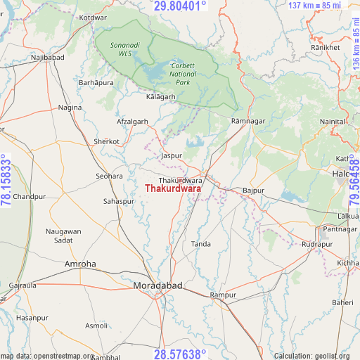
Thakurdwara GPS coordinates[2]
29° 11' 31.308" North, 78° 51' 41.22" East
| Map corner | latitude | longitude |
|---|---|---|
| Upper-left | 29.80401°, | 78.15833° |
| Center: | 29.19203°, | 78.86145° |
| Lower-right: | 28.57638°, | 79.56458° |
| Map W x H: | 136.5×136.5 km | = 84.8×84.8mi |
| max Lat: | 34.9274° ⇑10.3% North |
| Thakurdwara: | 29.19203° |
| min Lat: | ⇓89.7% South 8.09008° |
| min Long | Thakurdwara | max Long |
| 68.82655° | 78.86145° | 96.81° |
| W 57.6%⇐ | ⇒42.4% E |
Elevation
Elevation of Thakurdwara is 229 m = 751 ft, and this is 66.6 m = 219 ft below average elevation for this country.
| Max E: |
3681 m = 12077 ft | 44.2% |
| Avg. | 295.6 m = 970 ft | |
| Thakurdwara | 229 m = 751 ft | |
Min E: |
1 m = 3 ft | 55.8% |
See also: India elevation on elevation.city.
Geographical zone
Thakurdwara is located in North temperate zone (between Tropic of Cancer and the Arctic Circle). Distance of this Northern Tropic circle is 639.9 km =397.6 mi to South.| Distance of | km | miles | from Thakurdwara |
|---|---|---|---|
| North Pole | 6761.2 | 4201.2 | to North |
| Arctic Circle | 4155.3 | 2582 | to North |
| Tropic Cancer | 639.9 | 397.6 | to South |
| Equator | 3245.8 | 2016.8 | to South |


Nearby cities:
15 places around Thakurdwara: (largest is in red/bold)
• Afzalgarh
28.9 km =18 mi,  320°
320°
• Bāzpur
24.3 km =15.1 mi,  100°
100°
• Dhāmpur
36.4 km =22.6 mi,  290°
290°
• Jaspur
10.2 km =6.3 mi,  341°
341°
• Kashipur
9.6 km =6 mi,  75°
75°
• Kālāgarh Project Colony
32.6 km =20.3 mi,  346°
346°
• Kānth
26.9 km =16.7 mi,  236°
236°
• Morādābād
40.1 km =24.9 mi,  191°
191°
• Rāmnagar
34.2 km =21.3 mi,  49°
49°
• Sahaspur
24.5 km =15.2 mi,  251°
251°
• Seohāra
26.6 km =16.5 mi,  274°
274°
• Sherkot
31.6 km =19.6 mi,  298°
298°
• Suār
26.3 km =16.3 mi,  133°
133°
• Tājpur
36.7 km =22.8 mi,  264°
264°
• Tānda
25.2 km =15.7 mi,  161°
161°
Sources, notices
• [Note1] Compared only with cities in India existing in our database
• [Src1] Map data: © OpenStreetMap contributors (CC-BY-SA)
• [Src2] Other city data from geonames.org with taken over terms of usage.
• [Src3] Geographical zone / Annual Mean Temperature by Robert A. Rohde @ Wikipedia
