Kālāgarh Project Colony geodata
Kālāgarh Project Colony (Uttarakhand) is a populated place; located in India in Asia/Kolkata (GMT+5.5) time zone. With population of 13,298 people, there are 2628 cities with bigger population in this country. Compared to other cities in India, 91.1% of cities are located further ↓South; 56.7% of cities are located further ←West and 65.4% of cities have lower elevation than Kālāgarh Project Colony. Note1
Current local time in Kālāgarh Project Colony:
01:49 AM, WednesdayDifference from your time zone: hours


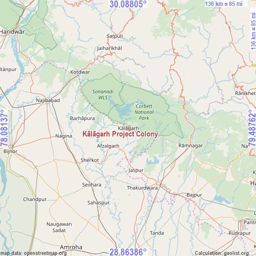
Kālāgarh Project Colony GPS coordinates[2]
29° 28' 40.08" North, 78° 47' 4.164" East
| Map corner | latitude | longitude |
|---|---|---|
| Upper-left | 30.08805°, | 78.08137° |
| Center: | 29.4778°, | 78.78449° |
| Lower-right: | 28.86386°, | 79.48762° |
| Map W x H: | 136.1×136.1 km | = 84.6×84.6mi |
| max Lat: | 34.9274° ⇑8.9% North |
| Kālāgarh Project Colony: | 29.4778° |
| min Lat: | ⇓91.1% South 8.09008° |
| min Long | Kālāgarh Proj | max Long |
| 68.82655° | 78.78449° | 96.81° |
| W 56.7%⇐ | ⇒43.3% E |
Elevation
Elevation of Kālāgarh Project Colony is 289 m = 948 ft, and this is 6.6 m = 22 ft below average elevation for this country.
| Max E: |
3681 m = 12077 ft | 34.6% |
| Avg. | 295.6 m = 970 ft | |
| Kālāgarh Project Colony | 289 m = 948 ft | |
Min E: |
1 m = 3 ft | 65.4% |
See also: India elevation on elevation.city.
Geographical zone
Kālāgarh Project Colony is located in North temperate zone (between Tropic of Cancer and the Arctic Circle). Distance of this Northern Tropic circle is 671.7 km =417.4 mi to South.| Distance of | km | miles | from Kālāgarh Project Colony |
|---|---|---|---|
| North Pole | 6729.4 | 4181.5 | to North |
| Arctic Circle | 4123.5 | 2562.2 | to North |
| Tropic Cancer | 671.7 | 417.4 | to South |
| Equator | 3277.6 | 2036.6 | to South |


Nearby cities:
15 places around Kālāgarh Project Colony: (largest is in red/bold)
• Afzalgarh
14.2 km =8.8 mi,  228°
228°
• Dhāmpur
32.5 km =20.2 mi, 234°
• Dugadda
40.2 km =25 mi,  335°
335°
• Jaspur
22.5 km =14 mi,  169°
169°
• Kashipur
33.8 km =21 mi,  150°
150°
• Kotdwāra
39.2 km =24.4 mi,  319°
319°
• Lansdowne
41.7 km =25.9 mi,  346°
346°
• Nagīna
33.9 km =21.1 mi,  263°
263°
• Najībābād
45.3 km =28.1 mi,  289°
289°
• Nihtaur
42.1 km =26.2 mi,  246°
246°
• Rāmnagar
34.6 km =21.5 mi,  105°
105°
• Sahaspur
42.6 km =26.5 mi,  201°
201°
• Seohāra
35.4 km =22 mi,  212°
212°
• Sherkot
26.4 km =16.4 mi, 230°
• Thakurdwara
32.6 km =20.3 mi, 166°
Sources, notices
• [Note1] Compared only with cities in India existing in our database
• [Src1] Map data: © OpenStreetMap contributors (CC-BY-SA)
• [Src2] Other city data from geonames.org with taken over terms of usage.
• [Src3] Geographical zone / Annual Mean Temperature by Robert A. Rohde @ Wikipedia
