Najībābād geodata
Najībābād (Uttar Pradesh) is a populated place; located in India in Asia/Kolkata (GMT+5.5) time zone. With population of 84,006 people, there are 527 cities with bigger population in this country. Compared to other cities in India, 91.6% of cities are located further ↓South; 52.7% of cities are located further ←West and 63.2% of cities have lower elevation than Najībābād. Note1


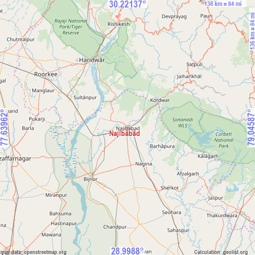
Najībābād GPS coordinates[2]
29° 36' 42.984" North, 78° 20' 33.864" East
| Map corner | latitude | longitude |
|---|---|---|
| Upper-left | 30.22137°, | 77.63962° |
| Center: | 29.61194°, | 78.34274° |
| Lower-right: | 28.9988°, | 79.04587° |
| Map W x H: | 135.9×135.9 km | = 84.4×84.4mi |
| max Lat: | 34.9274° ⇑8.4% North |
| Najībābād: | 29.61194° |
| min Lat: | ⇓91.6% South 8.09008° |
| min Long | Najībābād | max Long |
| 68.82655° | 78.34274° | 96.81° |
| W 52.7%⇐ | ⇒47.3% E |
Elevation
Elevation of Najībābād is 273 m = 896 ft, and this is 22.6 m = 74 ft below average elevation for this country.
| Max E: |
3681 m = 12077 ft | 36.8% |
| Avg. | 295.6 m = 970 ft | |
| Najībābād | 273 m = 896 ft | |
Min E: |
1 m = 3 ft | 63.2% |
See also: Najībābād elevation on elevation.city.
Geographical zone
Najībābād is located in North temperate zone (between Tropic of Cancer and the Arctic Circle). Distance of this Northern Tropic circle is 686.6 km =426.6 mi to South.| Distance of | km | miles | from Najībābād |
|---|---|---|---|
| North Pole | 6714.5 | 4172.2 | to North |
| Arctic Circle | 4108.6 | 2553 | to North |
| Tropic Cancer | 686.6 | 426.6 | to South |
| Equator | 3292.5 | 2045.9 | to South |


Nearby cities:
15 places around Najībābād: (largest is in red/bold)
• Afzalgarh
40.2 km =25 mi,  127°
127°
• Bijnor
33.2 km =20.6 mi,  216°
216°
• Dhāmpur
37.4 km =23.2 mi,  154°
154°
• Dugadda
33.8 km =21 mi,  50°
50°
• Haldaur
36.3 km =22.6 mi,  188°
188°
• Haridwar
41.3 km =25.7 mi,  334°
334°
• Jhālu
32.7 km =20.3 mi,  200°
200°
• Kotdwāra
22.9 km =14.2 mi, 49°
• Kīratpur
17.6 km =10.9 mi,  228°
228°
• Laksar
33.4 km =20.8 mi,  299°
299°
• Mandāwar
25.1 km =15.6 mi,  236°
236°
• Nagīna
20.7 km =12.9 mi, 154°
• Nihtaur
32.3 km =20.1 mi,  172°
172°
• Sherkot
38.8 km =24.1 mi,  144°
144°
• Sultānpur
27.5 km =17.1 mi,  305°
305°
Sources, notices
• [Note1] Compared only with cities in India existing in our database
• [Src1] Map data: © OpenStreetMap contributors (CC-BY-SA)
• [Src2] Other city data from geonames.org with taken over terms of usage.
• [Src3] Geographical zone / Annual Mean Temperature by Robert A. Rohde @ Wikipedia
