Vikārābād geodata
Vikārābād (Telangana) is a seat of a second-order administrative division; located in India in Asia/Kolkata (GMT+5.5) time zone. With population of 43,337 people, there are 1019 cities with bigger population in this country. Compared to other cities in India, 73.9% of cities are located further ↑North; 52.3% of cities are located further →East and 90% of cities have lower elevation than Vikārābād. Note1


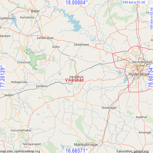
Vikārābād GPS coordinates[2]
17° 20' 17.16" North, 77° 54' 15.876" East
| Map corner | latitude | longitude |
|---|---|---|
| Upper-left | 18.00804°, | 77.20129° |
| Center: | 17.3381°, | 77.90441° |
| Lower-right: | 16.66571°, | 78.60754° |
| Map W x H: | 149.3×149.3 km | = 92.8×92.8mi |
| max Lat: | 34.9274° ⇑73.9% North |
| Vikārābād: | 17.3381° |
| min Lat: | ⇓26.1% South 8.09008° |
| min Long | Vikārābād | max Long |
| 68.82655° | 77.90441° | 96.81° |
| W 47.7%⇐ | ⇒52.3% E |
Elevation
Elevation of Vikārābād is 638 m = 2093 ft, and this is 342.4 m = 1123 ft above average elevation for this country.
| Max E: |
3681 m = 12077 ft | 10% |
| Vikārābād | 638 m 2093 ft | |
| Avg. | 295.6 m = 970 ft | |
Min E: |
1 m = 3 ft | 90% |
See also: Vikārābād elevation on elevation.city.
Geographical zone
Vikārābād is located in North Torrid zone (between Equator and Tropic of Cancer). Distance of this Northern Tropic circle is 678.1 km =421.4 mi to North.| Distance of | km | miles | from Vikārābād |
|---|---|---|---|
| North Pole | 8079.2 | 5020.2 | to North |
| Arctic Circle | 5473.4 | 3401 | to North |
| Tropic Cancer | 678.1 | 421.4 | to North |
| Equator | 1927.8 | 1197.9 | to South |


Nearby cities:
15 places around Vikārābād: (largest is in red/bold)
• Andol
56.1 km =34.9 mi,  19°
19°
• Chincholi
53.4 km =33.2 mi,  285°
285°
• Farrukhnagar
43 km =26.7 mi,  132°
132°
• Hyderabad
58.8 km =36.5 mi,  85°
85°
• Kurgunta
60.2 km =37.4 mi,  254°
254°
• Kūkatpalli
56.4 km =35 mi,  73°
73°
• Patancheru
43.9 km =27.3 mi,  60°
60°
• Quthbullapur
61.5 km =38.2 mi, 72°
• Sadāseopet
31.7 km =19.7 mi,  9°
9°
• Sangāreddi
37.3 km =23.2 mi,  31°
31°
• Serilingampalle
45.6 km =28.3 mi, 67°
• Singāpur
27.7 km =17.2 mi, 58°
• Srīrāmnagar
38.1 km =23.7 mi,  102°
102°
• Tāndūr
36.2 km =22.5 mi, 254°
• Zahirābād
49.5 km =30.8 mi,  320°
320°
Sources, notices
• [Note1] Compared only with cities in India existing in our database
• [Src1] Map data: © OpenStreetMap contributors (CC-BY-SA)
• [Src2] Other city data from geonames.org with taken over terms of usage.
• [Src3] Geographical zone / Annual Mean Temperature by Robert A. Rohde @ Wikipedia
