As Samawah geodata
As Samawah (Al Muthanná) is a seat of a first-order administrative division; located in Iraq in Asia/Baghdad (GMT+3) time zone. With population of 152,890 people, there are 20 cities with bigger population in this country. Compared to other cities in Iraq, 88.7% of cities are located further ↑North; 72.5% of cities are located further ←West and 83.8% of cities have higher elevation than As Samawah. Note1


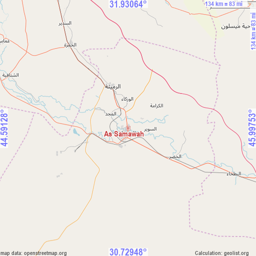
As Samawah GPS coordinates[2]
31° 19' 55.128" North, 45° 17' 39.84" East
| Map corner | latitude | longitude |
|---|---|---|
| Upper-left | 31.93064°, | 44.59128° |
| Center: | 31.33198°, | 45.2944° |
| Lower-right: | 30.72948°, | 45.99753° |
| Map W x H: | 133.6×133.6 km | = 83×83mi |
| max Lat: | 37.22781° ⇑88.7% North |
| As Samawah: | 31.33198° |
| min Lat: | ⇓11.3% South 29.97421° |
| min Long | As Samawah | max Long |
| 40.28586° | 45.2944° | 48.47309° |
| W 72.5%⇐ | ⇒27.5% E |
Elevation
Elevation of As Samawah is 15 m = 49 ft, and this is 278 m = 912 ft below average elevation for this country.
| Max E: |
1316 m = 4318 ft | 83.8% |
| Avg. | 293 m = 961 ft | |
| As Samawah | 15 m = 49 ft | |
Min E: |
1 m = 3 ft | 16.2% |
See also: As Samawah elevation on elevation.city.
Geographical zone
As Samawah is located in North temperate zone (between Tropic of Cancer and the Arctic Circle). Distance of this Northern Tropic circle is 877.9 km =545.5 mi to South.| Distance of | km | miles | from As Samawah |
|---|---|---|---|
| North Pole | 6523.3 | 4053.4 | to North |
| Arctic Circle | 3917.4 | 2434.2 | to North |
| Tropic Cancer | 877.9 | 545.5 | to South |
| Equator | 3483.8 | 2164.7 | to South |


Nearby cities:
15 places around As Samawah: (largest is in red/bold)
• Ad Dīwānīyah
81.4 km =50.6 mi,  334°
334°
• Al Manādhirah
99.7 km =62 mi,  309°
309°
• Al Mishkhāb
92.6 km =57.5 mi,  304°
304°
• Al Ḩamzah
53 km =32.9 mi, 325°
• Al Ḩayy
117.4 km =72.9 mi,  37°
37°
• Ar Rifā‘ī
88.4 km =54.9 mi,  60°
60°
• Ar Rumaythah
23.5 km =14.6 mi,  338°
338°
• As Salmān
116.8 km =72.6 mi,  218°
218°
• Ash Shaţrah
83.8 km =52.1 mi,  84°
84°
• Ash Shāmīyah
96.1 km =59.7 mi,  316°
316°
• Kufa
113.7 km =70.6 mi, 314°
• Nahiyat Ghammas
78.6 km =48.8 mi, 305°
• Nasiriyah
96.5 km =60 mi,  108°
108°
• Nāḩiyat ash Shināfīyah
67.5 km =41.9 mi,  294°
294°
• ‘Afak
81.5 km =50.6 mi,  356°
356°
Sources, notices
• [Note1] Compared only with cities in Iraq existing in our database
• [Src1] Map data: © OpenStreetMap contributors (CC-BY-SA)
• [Src2] Other city data from geonames.org with taken over terms of usage.
• [Src3] Geographical zone / Annual Mean Temperature by Robert A. Rohde @ Wikipedia
