‘Afak geodata
‘Afak (Al Qādisīyah) is a seat of a second-order administrative division; located in Iraq in Asia/Baghdad (GMT+3) time zone. With population of 21,888 people, there are 66 cities with bigger population in this country. Compared to other cities in Iraq, 76.8% of cities are located further ↑North; 70.4% of cities are located further ←West and 76.8% of cities have higher elevation than ‘Afak. Note1


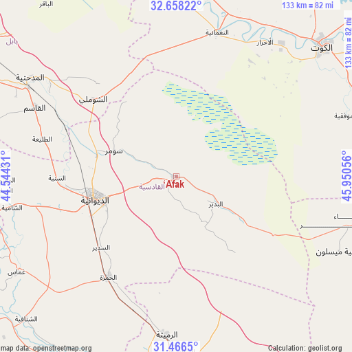
‘Afak GPS coordinates[2]
32° 3' 51.48" North, 45° 14' 50.748" East
| Map corner | latitude | longitude |
|---|---|---|
| Upper-left | 32.65822°, | 44.54431° |
| Center: | 32.0643°, | 45.24743° |
| Lower-right: | 31.4665°, | 45.95056° |
| Map W x H: | 132.5×132.5 km | = 82.3×82.3mi |
| max Lat: | 37.22781° ⇑76.8% North |
| ‘Afak: | 32.0643° |
| min Lat: | ⇓23.2% South 29.97421° |
| min Long | ‘Afak | max Long |
| 40.28586° | 45.24743° | 48.47309° |
| W 70.4%⇐ | ⇒29.6% E |
Elevation
Elevation of ‘Afak is 25 m = 82 ft, and this is 268 m = 879 ft below average elevation for this country.
| Max E: |
1316 m = 4318 ft | 76.8% |
| Avg. | 293 m = 961 ft | |
| ‘Afak | 25 m = 82 ft | |
Min E: |
1 m = 3 ft | 23.2% |
See also: Iraq elevation on elevation.city.
Geographical zone
‘Afak is located in North temperate zone (between Tropic of Cancer and the Arctic Circle). Distance of this Northern Tropic circle is 959.3 km =596.1 mi to South.| Distance of | km | miles | from ‘Afak |
|---|---|---|---|
| North Pole | 6441.8 | 4002.7 | to North |
| Arctic Circle | 3836 | 2383.6 | to North |
| Tropic Cancer | 959.3 | 596.1 | to South |
| Equator | 3565.2 | 2215.3 | to South |


Nearby cities:
15 places around ‘Afak: (largest is in red/bold)
• Ad Dīwānīyah
31.4 km =19.5 mi,  255°
255°
• Al Hāshimīyah
64.5 km =40.1 mi,  301°
301°
• Al Kūt
73.2 km =45.5 mi,  47°
47°
• Al Manādhirah
73.9 km =45.9 mi, 256°
• Al Mishkhāb
77.2 km =48 mi,  248°
248°
• Al Ḩamzah
45.6 km =28.3 mi,  214°
214°
• Al Ḩayy
76 km =47.2 mi,  80°
80°
• An Nu‘mānīyah
56.9 km =35.4 mi,  15°
15°
• Ar Rumaythah
59.7 km =37.1 mi,  183°
183°
• As Samawah
81.5 km =50.6 mi, 176°
• Ash Shāmīyah
62 km =38.5 mi, 259°
• Imam Qasim
59.1 km =36.7 mi, 296°
• Kufa
76.1 km =47.3 mi,  268°
268°
• Nahiyat Ghammas
69.2 km =43 mi,  238°
238°
• Nāḩiyat ash Shināfīyah
77.9 km =48.4 mi,  226°
226°
Sources, notices
• [Note1] Compared only with cities in Iraq existing in our database
• [Src1] Map data: © OpenStreetMap contributors (CC-BY-SA)
• [Src2] Other city data from geonames.org with taken over terms of usage.
• [Src3] Geographical zone / Annual Mean Temperature by Robert A. Rohde @ Wikipedia
