‘Alī al Gharbī geodata
‘Alī al Gharbī (Maysan) is a seat of a second-order administrative division; located in Iraq in Asia/Baghdad (GMT+3) time zone. With population of 19,711 people, there are 69 cities with bigger population in this country. Compared to other cities in Iraq, 73.2% of cities are located further ↑North; 87.3% of cities are located further ←West and 84.5% of cities have higher elevation than ‘Alī al Gharbī. Note1


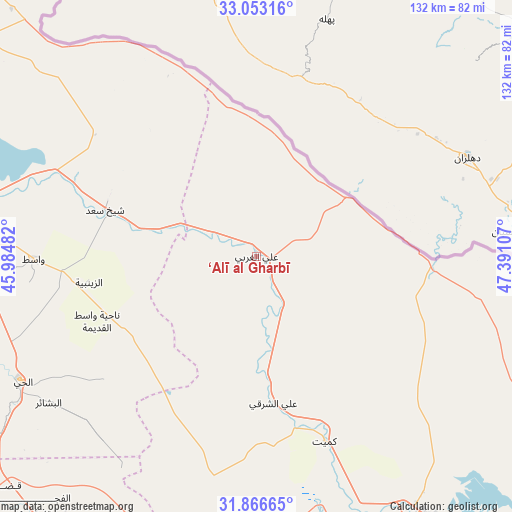
‘Alī al Gharbī GPS coordinates[2]
32° 27' 42.696" North, 46° 41' 16.584" East
| Map corner | latitude | longitude |
|---|---|---|
| Upper-left | 33.05316°, | 45.98482° |
| Center: | 32.46186°, | 46.68794° |
| Lower-right: | 31.86665°, | 47.39107° |
| Map W x H: | 131.9×131.9 km | = 82×82mi |
| max Lat: | 37.22781° ⇑73.2% North |
| ‘Alī al Gharbī: | 32.46186° |
| min Lat: | ⇓26.8% South 29.97421° |
| min Long | ‘Alī al Ghar | max Long |
| 40.28586° | 46.68794° | 48.47309° |
| W 87.3%⇐ | ⇒12.7% E |
Elevation
Elevation of ‘Alī al Gharbī is 14 m = 46 ft, and this is 279 m = 915 ft below average elevation for this country.
| Max E: |
1316 m = 4318 ft | 84.5% |
| Avg. | 293 m = 961 ft | |
| ‘Alī al Gharbī | 14 m = 46 ft | |
Min E: |
1 m = 3 ft | 15.5% |
See also: Iraq elevation on elevation.city.
Geographical zone
‘Alī al Gharbī is located in North temperate zone (between Tropic of Cancer and the Arctic Circle). Distance of this Northern Tropic circle is 1003.5 km =623.5 mi to South.| Distance of | km | miles | from ‘Alī al Gharbī |
|---|---|---|---|
| North Pole | 6397.6 | 3975.3 | to North |
| Arctic Circle | 3791.8 | 2356.1 | to North |
| Tropic Cancer | 1003.5 | 623.5 | to South |
| Equator | 3609.4 | 2242.8 | to South |


Nearby cities:
15 places around ‘Alī al Gharbī: (largest is in red/bold)
• Al Kaḩlā’
105.2 km =65.4 mi,  147°
147°
• Al Kūt
81.8 km =50.8 mi,  273°
273°
• Al Maymūnah
91 km =56.5 mi,  163°
163°
• Al Ḩayy
68.5 km =42.6 mi,  242°
242°
• Al ‘Amārah
81.8 km =50.8 mi, 148°
• Al ‘Azīzīyah
159.9 km =99.4 mi,  288°
288°
• An Nu‘mānīyah
120 km =74.6 mi,  275°
275°
• Ar Rifā‘ī
98.9 km =61.5 mi,  213°
213°
• Ash Shaţrah
126.8 km =78.8 mi,  202°
202°
• Badrah
101.2 km =62.9 mi,  315°
315°
• Nasiriyah
161.3 km =100.2 mi,  194°
194°
• Nāḩiyat Alī ash Sharqī
38.1 km =23.7 mi,  171°
171°
• Nāḩiyat al Fuhūd
165.9 km =103.1 mi,  178°
178°
• Qal‘at Şāliḩ
118.5 km =73.6 mi, 151°
• ‘Afak
142.5 km =88.5 mi,  251°
251°
Sources, notices
• [Note1] Compared only with cities in Iraq existing in our database
• [Src1] Map data: © OpenStreetMap contributors (CC-BY-SA)
• [Src2] Other city data from geonames.org with taken over terms of usage.
• [Src3] Geographical zone / Annual Mean Temperature by Robert A. Rohde @ Wikipedia
