Shahre Jadide Andisheh geodata
Shahre Jadide Andisheh (Tehrān) is a populated place; located in Iran in Asia/Tehran (GMT+3.5) time zone. With population of 80,000 people, there are 84 cities with bigger population in this country. Compared to other cities in Iran, 64.9% of cities are located further ↓South; 52.8% of cities are located further →East and 50.6% of cities have lower elevation than Shahre Jadide Andisheh. Note1
Current local time in Shahre Jadide Andisheh:
02:06 PM, TuesdayDifference from your time zone: hours


Shahre Jadide Andisheh GPS coordinates[2]
35° 40' 49.08" North, 51° 1' 9.48" East
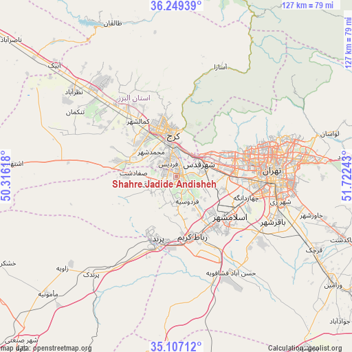
| Map corner | latitude | longitude |
|---|---|---|
| Upper-left | 36.24939°, | 50.31618° |
| Center: | 35.6803°, | 51.0193° |
| Lower-right: | 35.10712°, | 51.72243° |
| Map W x H: | 127×127 km | = 78.9×78.9mi |
| max Lat: | 39.6482° ⇑35.1% North |
| Shahre Jadide Andisheh: | 35.6803° |
| min Lat: | ⇓64.9% South 25.2919° |
| min Long | Shahre Jadide A | max Long |
| 44.38416° | 51.0193° | 61.9965° |
| W 47.2%⇐ | ⇒52.8% E |
Elevation
Elevation of Shahre Jadide Andisheh is 1180 m = 3871 ft, and this is 131 m = 430 ft above average elevation for this country.
| Max E: |
2564 m = 8412 ft | 49.4% |
| Shahre Jadide Andisheh | 1180 m 3871 ft | |
| Avg. | 1049 m = 3442 ft | |
Min E: |
-24 m = -79 ft | 50.6% |
See also: Shahre Jadide Andisheh elevation on elevation.city.
Geographical zone
Shahre Jadide Andisheh is located in North temperate zone (between Tropic of Cancer and the Arctic Circle). Distance of this Northern Tropic circle is 1361.4 km =845.9 mi to South.| Distance of | km | miles | from Shahre Jadide Andisheh |
|---|---|---|---|
| North Pole | 6039.8 | 3753 | to North |
| Arctic Circle | 3433.9 | 2133.7 | to North |
| Tropic Cancer | 1361.4 | 845.9 | to South |
| Equator | 3967.3 | 2465.2 | to South |


Nearby cities:
15 places around Shahre Jadide Andisheh: (largest is in red/bold)
• Eshtehārd
59.2 km =36.8 mi,  274°
274°
• Eslāmshahr
24.1 km =15 mi,  126°
126°
• Hashtgerd
43.8 km =27.2 mi,  315°
315°
• Karaj
17.1 km =10.6 mi,  351°
351°
• Malārd
4.2 km =2.6 mi,  247°
247°
• Naz̧arābād
48.1 km =29.9 mi,  309°
309°
• Qarchak
57.6 km =35.8 mi,  119°
119°
• Rey
39.2 km =24.4 mi,  104°
104°
• Robāţ Karīm
22.5 km =14 mi,  165°
165°
• Shahr-e Qods
9.3 km =5.8 mi,  60°
60°
• Shahrak-e Emām Ḩasan
36.4 km =22.6 mi, 125°
• Shahrīār
4.2 km =2.6 mi, 124°
• Tajrīsh
39.2 km =24.4 mi,  69°
69°
• Tehran
36.4 km =22.6 mi,  87°
87°
• Ţāleb ābād
50.4 km =31.3 mi,  113°
113°
Sources, notices
• [Note1] Compared only with cities in Iran existing in our database
• [Src1] Map data: © OpenStreetMap contributors (CC-BY-SA)
• [Src2] Other city data from geonames.org with taken over terms of usage.
• [Src3] Geographical zone / Annual Mean Temperature by Robert A. Rohde @ Wikipedia
