Tehran geodata
Tehran (Tehrān) is a capital of a political entity; located in Iran in Asia/Tehran (GMT+3.5) time zone. With population of 7,153,309 people, there are 0 cities with bigger population in this country. Compared to other cities in Iran, 65.1% of cities are located further ↓South; 51% of cities are located further ←West and 50.3% of cities have lower elevation than Tehran. Note1


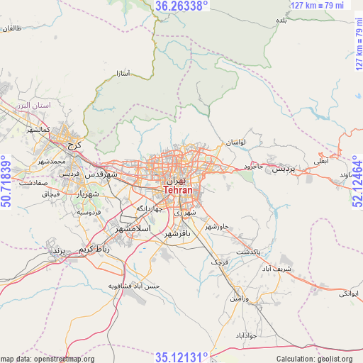
Tehran GPS coordinates[2]
35° 41' 39.804" North, 51° 25' 17.436" East
| Map corner | latitude | longitude |
|---|---|---|
| Upper-left | 36.26338°, | 50.71839° |
| Center: | 35.69439°, | 51.42151° |
| Lower-right: | 35.12131°, | 52.12464° |
| Map W x H: | 127×127 km | = 78.9×78.9mi |
| max Lat: | 39.6482° ⇑34.9% North |
| Tehran: | 35.69439° |
| min Lat: | ⇓65.1% South 25.2919° |
| min Long | Tehran | max Long |
| 44.38416° | 51.42151° | 61.9965° |
| W 51%⇐ | ⇒49% E |
Elevation
Elevation of Tehran is 1178 m = 3865 ft, and this is 129 m = 423 ft above average elevation for this country.
| Max E: |
2564 m = 8412 ft | 49.7% |
| Tehran | 1178 m 3865 ft | |
| Avg. | 1049 m = 3442 ft | |
Min E: |
-24 m = -79 ft | 50.3% |
See also: Tehran elevation on elevation.city.
Geographical zone
Tehran is located in North temperate zone (between Tropic of Cancer and the Arctic Circle). Distance of this Northern Tropic circle is 1362.9 km =846.9 mi to South.| Distance of | km | miles | from Tehran |
|---|---|---|---|
| North Pole | 6038.2 | 3752 | to North |
| Arctic Circle | 3432.3 | 2132.7 | to North |
| Tropic Cancer | 1362.9 | 846.9 | to South |
| Equator | 3968.8 | 2466.1 | to South |


Nearby cities:
15 places around Tehran: (largest is in red/bold)
• Eqbālīyeh
44.8 km =27.8 mi,  166°
166°
• Eslāmshahr
23.1 km =14.4 mi,  226°
226°
• Karaj
41.7 km =25.9 mi,  291°
291°
• Malārd
40.3 km =25 mi,  265°
265°
• Pākdasht
33.7 km =20.9 mi,  135°
135°
• Qarchak
32.7 km =20.3 mi,  154°
154°
• Rey
11.3 km =7 mi, 171°
• Robāţ Karīm
38.5 km =23.9 mi, 232°
• Shahr-e Qods
28.4 km =17.6 mi,  276°
276°
• Shahrak-e Emām Ḩasan
23.9 km =14.9 mi,  196°
196°
• Shahre Jadide Andisheh
36.4 km =22.6 mi, 267°
• Shahrīār
33.1 km =20.6 mi,  263°
263°
• Sharīfābād
44.3 km =27.5 mi,  132°
132°
• Tajrīsh
12.2 km =7.6 mi,  1°
1°
• Ţāleb ābād
23.7 km =14.7 mi,  155°
155°
In other languages:
- In Spanish: Teherán
- In France: Téhéran
- In German: Teheran
- In Italian: Teheran
- In Russian: Тегеран
Sources, notices
• [Note1] Compared only with cities in Iran existing in our database
• [Src1] Map data: © OpenStreetMap contributors (CC-BY-SA)
• [Src2] Other city data from geonames.org with taken over terms of usage.
• [Src3] Geographical zone / Annual Mean Temperature by Robert A. Rohde @ Wikipedia
